File:Franklin Township map.png

預覽大小:600 × 600 像素。 其他解析度:240 × 240 像素 | 480 × 480 像素 | 768 × 768 像素 | 1,024 × 1,024 像素 | 1,838 × 1,838 像素。
原始檔案 (1,838 × 1,838 像素,檔案大小:1.23 MB,MIME 類型:image/png)
| 描述 |
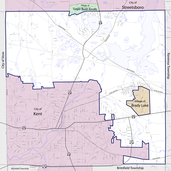
English: Map of Franklin Township in Portage County, Ohio, showing boundaries and roads with main roads highlighted. Base map from the U.S. Census Bureau's 2009 Boundary and Annexation Survey |
|||
| 日期 | ||||
| 來源 | http://ftp2.census.gov/geo/pvs/bas/bas09/st39_oh/mcd/m3928392_franklin/BAS09M33913328392_001.pdf | |||
| 作者 | U.S. Census Bureau, Jon Ridinger | |||
| 授權許可 (重用此檔案) |
我,本作品的著作權持有者,決定用以下授權條款發佈本作品:
此檔案採用創用CC 姓名標示 3.0 未在地化版本授權條款。
您可以選擇您需要的授權條款。 |

檔案歷史
點選日期/時間以檢視該時間的檔案版本。
| 日期/時間 | 縮圖 | 尺寸 | 使用者 | 備註 | |
|---|---|---|---|---|---|
| 目前 | 2010年9月9日 (四) 19:20 | | 1,838 × 1,838(1.23 MB) | JonRidinger | forgot main road labels |
| 2010年9月9日 (四) 01:33 |  | 1,838 × 1,838(1.23 MB) | JonRidinger | minor adjustments | |
| 2010年9月9日 (四) 00:47 |  | 1,838 × 1,838(1.23 MB) | JonRidinger | {{Information |Description={{en|1=Map of Franklin Township in Portage County, Ohio, showing boundaries and main roads. Base map from 2009 Boundary and Annexation Survey.}} |Source=http://ftp2.census.gov/geo/p |
檔案用途
下列頁面有用到此檔案:
全域檔案使用狀況
以下其他 wiki 使用了這個檔案:
- en.wikipedia.org 的使用狀況