此為最大尺寸。
已授權您依據自由軟體基金會 發行的無固定段落、封面文字和封底文字GNU自由文件授權條款 GNU自由文件授權條款 中。http://www.gnu.org/copyleft/fdl.html GFDL GNU Free Documentation License true true
此檔案採用創用CC 姓名標示-相同方式分享 3.0 未在地化版本 授權條款。
您可以自由:
分享 – 複製、發佈和傳播本作品重新修改 – 創作演繹作品
惟需遵照下列條件:
姓名標示 – 您必須指名出正確的製作者,和提供授權條款的連結,以及表示是否有對內容上做出變更。您可以用任何合理的方式來行動,但不得以任何方式表明授權條款是對您許可或是由您所使用。相同方式分享 – 如果您利用本素材進行再混合、轉換或創作,您必須基於如同原先的相同或兼容的條款 ,來分布您的貢獻成品。
已新增授權條款標題至此檔案,作為GFDL授權更新 的一部份。 http://creativecommons.org/licenses/by-sa/3.0/ CC BY-SA 3.0 Creative Commons Attribution-Share Alike 3.0 true true
我,本作品的著作權持有者,決定用以下授權條款發佈本作品:
已授權您依據自由軟體基金會 發行的無固定段落、封面文字和封底文字GNU自由文件授權條款 GNU自由文件授權條款 中。 受免責聲明 的約束。http://www.gnu.org/copyleft/fdl.html GFDL GNU Free Documentation License true true
The original description page was
here . All following user names refer to en.wikipedia.
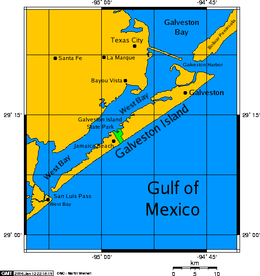
2006-01-12 21:50 Kharker 534×566×8 (34675 bytes) A map of [[Galveston Island]], a [[barrier island]] on the [[Texas]] Gulf coast in the [[United States]], about 50 miles (80 kilometers) south of the city of [[Houston, Texas|Houston]]. The map was created with this [http://www.aquarius.geomar.de/omc/ on 檔案歷史
點選日期/時間以檢視該時間的檔案版本。
日期/時間 縮圖 尺寸 使用者 備註 目前 2007年12月22日 (六) 10:07 534 × 566(34 KB) PaulVIF {{Information |Description={{en|A map of en:Galveston Island , a en:barrier island on the en:Texas Gulf coast in the en:United States , about 50 miles (80 kilometers) south of the city of Houston . The map was crea
檔案用途
全域檔案使用狀況
以下其他 wiki 使用了這個檔案:
arz.wikipedia.org 的使用狀況
de.wikipedia.org 的使用狀況
en.wikipedia.org 的使用狀況
es.wikipedia.org 的使用狀況
eu.wikipedia.org 的使用狀況
fr.wikipedia.org 的使用狀況
fr.wiktionary.org 的使用狀況
id.wikipedia.org 的使用狀況
it.wikipedia.org 的使用狀況
pt.wikipedia.org 的使用狀況
ru.wikipedia.org 的使用狀況
simple.wikipedia.org 的使用狀況
www.wikidata.org 的使用狀況


