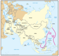
File:Geographic Boundaries of the First and Second Island Chains.png

預覽大小:621 × 600 像素。 其他解析度:248 × 240 像素 | 497 × 480 像素 | 795 × 768 像素 | 1,060 × 1,024 像素 | 1,387 × 1,340 像素。
原始檔案 (1,387 × 1,340 像素,檔案大小:51 KB,MIME 類型:image/png)
檔案歷史
點選日期/時間以檢視該時間的檔案版本。
| 日期/時間 | 縮圖 | 尺寸 | 使用者 | 備註 | |
|---|---|---|---|---|---|
| 目前 | 2018年3月8日 (四) 00:24 |  | 1,387 × 1,340(51 KB) | Ras67 | new extracted and cropped from the PDF |
| 2016年11月7日 (一) 11:32 |  | 1,434 × 1,378(104 KB) | Ricky22p | Better quality version extracted from the same PDF file using GNOME Document Viewer. | |
| 2006年5月26日 (五) 08:29 |  | 1,431 × 1,121(89 KB) | Shizhao | {{Information |Description=Figure 2. Geographic Boundaries of the First and Second Island Chains |Source=Image:China Report 2006.pdf |Date=05/23/06 |Author=DoD |Permission={{PD-USGov-Military}} |other_versions= }} [[Category:Chinas' Military Power Re |
檔案用途
下列頁面有用到此檔案:
全域檔案使用狀況
以下其他 wiki 使用了這個檔案:
- ar.wikipedia.org 的使用狀況
- de.wikipedia.org 的使用狀況
- en.wikipedia.org 的使用狀況
- fa.wikipedia.org 的使用狀況
- fr.wikipedia.org 的使用狀況
- id.wikipedia.org 的使用狀況
- it.wikipedia.org 的使用狀況
- ja.wikipedia.org 的使用狀況
- ko.wikipedia.org 的使用狀況
- no.wikipedia.org 的使用狀況
- pt.wikipedia.org 的使用狀況
- uk.wikipedia.org 的使用狀況
- vi.wikipedia.org 的使用狀況
- www.wikidata.org 的使用狀況

