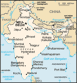
File:India map mod.png
India_map_mod.png (324 × 351 像素,檔案大小:17 KB,MIME 類型:image/png)
檔案歷史
點選日期/時間以檢視該時間的檔案版本。
| 日期/時間 | 縮圖 | 尺寸 | 使用者 | 備註 | |
|---|---|---|---|---|---|
| 目前 | 2011年3月14日 (一) 01:53 |  | 324 × 351(17 KB) | Ras67 | cropped |
| 2007年5月23日 (三) 12:31 |  | 330 × 355(22 KB) | Jungpionier | ||
| 2007年4月13日 (五) 06:11 |  | 330 × 355(23 KB) | Elya | update Bengaluru/Bangalore | |
| 2006年8月4日 (五) 09:33 |  | 330 × 355(22 KB) | Jungpionier | Tuttukkudi und Kozhikode entfernt | |
| 2006年8月3日 (四) 14:53 |  | 330 × 355(23 KB) | Jungpionier | Marmagao und Kandla entfernt (zu unbedeutend); Jaipur ergänzt; Imphal durch Gauhati ersetzt | |
| 2006年8月3日 (四) 12:11 |  | 330 × 355(23 KB) | Jungpionier | Bhubaneshwar ergänzt | |
| 2006年8月3日 (四) 09:51 |  | 330 × 355(23 KB) | Jungpionier | Haldia (falsche Lage, zu unbedeutend) entfernt, Patna eingefügt | |
| 2006年6月30日 (五) 12:50 |  | 330 × 355(23 KB) | Jungpionier | ||
| 2006年1月11日 (三) 10:17 |  | 330 × 355(21 KB) | Tzzzpfff~commonswiki | Städte umbenannt, Schriften korrigiert, Meilenmaßstab entfernt | |
| 2005年12月20日 (二) 14:35 |  | 330 × 355(24 KB) | Chnodomar~commonswiki | This image was copied from wikipedia:de. The original description was: {{GFDL}} map of india modified the frontier disputes of china and india is show in this map. the Aksai Chin is administrated by china, claimed by india; the most territories of Aruna |
檔案用途
下列2個頁面有用到此檔案:
全域檔案使用狀況
以下其他 wiki 使用了這個檔案:
- af.wikipedia.org 的使用狀況
- de.wikipedia.org 的使用狀況
- de.wiktionary.org 的使用狀況
- en.wikipedia.org 的使用狀況
- eo.wikipedia.org 的使用狀況
- frr.wikipedia.org 的使用狀況
- ko.wikipedia.org 的使用狀況
- kw.wikipedia.org 的使用狀況
- la.wikipedia.org 的使用狀況
- mi.wikipedia.org 的使用狀況
- nl.wikipedia.org 的使用狀況
- to.wikipedia.org 的使用狀況


