File:Ionian Revolt Campaign Map.png
預覽大小:493 × 599 像素。 其他解析度:197 × 240 像素 | 395 × 480 像素 | 632 × 768 像素 | 842 × 1,024 像素 | 1,645 × 2,000 像素。
原始檔案 (1,645 × 2,000 像素,檔案大小:4.24 MB,MIME 類型:image/png)
| 描述 |
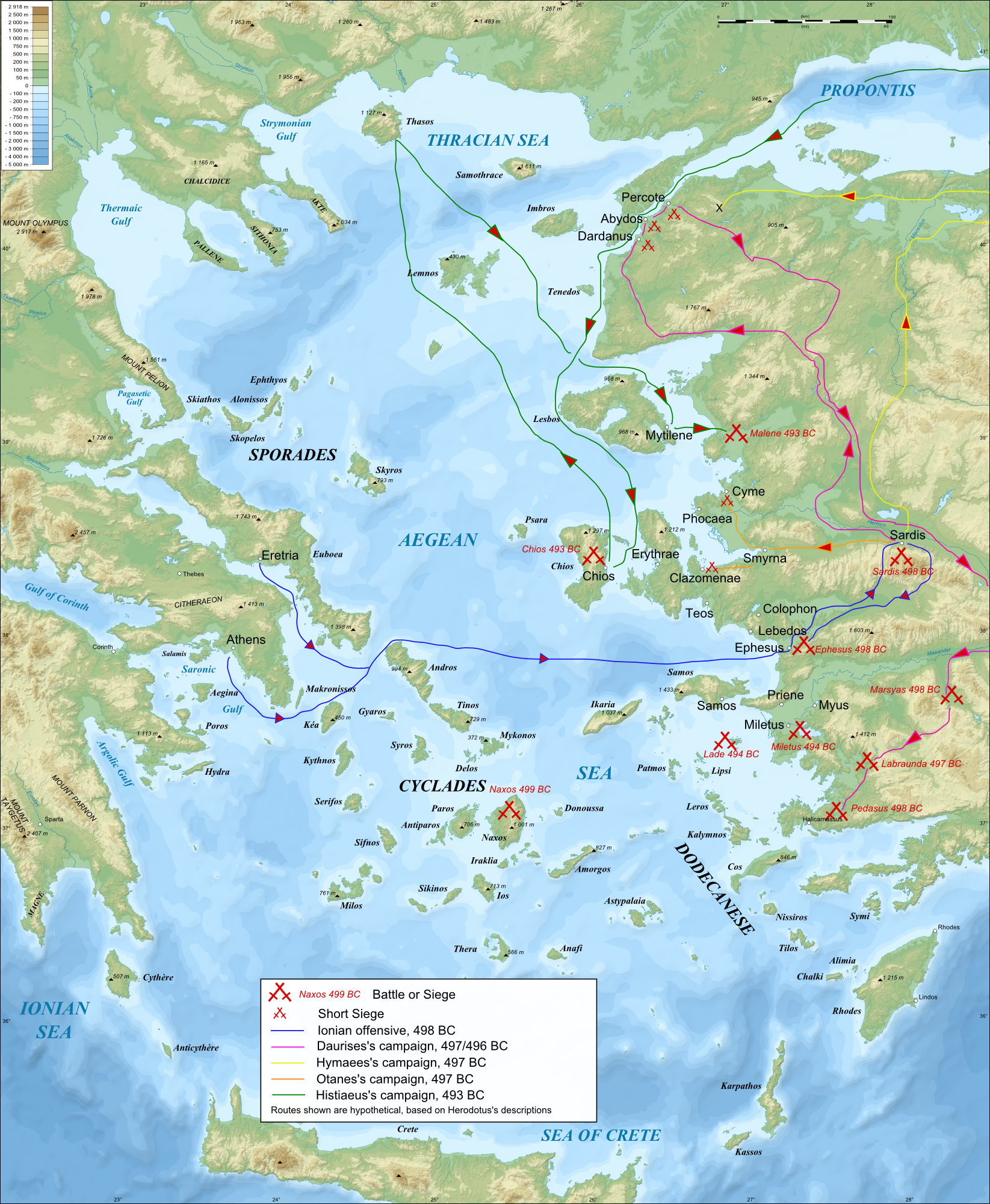
English: Bathymetric/Topographical map of the Aegean area in c.500 BC, showing major events of the Ionian Revolt.
|
| 日期 | (UTC) |
| 來源 | |
| 作者 |
|
| 其他版本 |
|


| 這是一張修飾過的圖片,即本圖片是用軟體修改過後的版本,修改的方式或內容有:Modified map to more ancient names, and constructed campaign map of Ionina revolt。原版圖片來源:Aegean Sea map bathymetry-fr.svg。修改者:MinisterForBadTimes。
|
我,本作品的著作權持有者,決定用以下授權條款發佈本作品:

|
已授權您依據自由軟體基金會發行的無固定段落、封面文字和封底文字GNU自由文件授權條款1.2版或任意後續版本,對本檔進行複製、傳播和/或修改。該協議的副本列在GNU自由文件授權條款中。 |
您可以選擇您需要的授權條款。
原始上傳日誌
This image is a derivative work of the following images:
- File:Aegean_Sea_map_bathymetry-fr.svg licensed with Cc-by-sa-3.0,2.5,2.0,1.0, GFDL
- 2009-02-08T00:35:16Z Sting 3750x4560 (3597775 Bytes) Correcting display bug - new try - step #2
- 2009-02-08T00:29:02Z Sting 3750x4560 (410188 Bytes) Correcting display bug - new try - step #1
- 2009-02-08T00:14:50Z Sting 3750x4560 (3740562 Bytes) Correcting display bug
- 2009-02-06T07:54:54Z Future Perfect at Sunrise 3750x4560 (3742390 Bytes) null edit, re-uploading to try to force display to be reset, background image wasn't displaying
- 2009-02-06T07:52:12Z Future Perfect at Sunrise 3750x4560 (3742390 Bytes) null edit, re-uploading to try to force display to be reset, background image wasn't displaying
- 2008-09-28T21:11:49Z Sting 3750x4560 (3742390 Bytes) Completely new background using ETOPO1 data ; new standard colors ; some additional labels
- 2007-11-27T13:16:40Z Sting 3750x4560 (4078448 Bytes) Elevation on Chios
- 2007-11-26T23:25:43Z Sting 3750x4560 (4078446 Bytes) correction
- 2007-11-21T22:42:53Z Sting 3750x4560 (4079234 Bytes) Additional sea names
- 2007-11-21T20:21:26Z Sting 3750x4560 (4078039 Bytes) Additional key
- 2007-11-21T19:10:35Z Sting 3750x4560 (4072878 Bytes) {{Information |Description=Bathymetric map in French of the [[:Category:Aegean Sea|Aegean Sea]], Mediterranean Sea |Source=Own work ;Raster relief background map : [http://www2.jpl.nasa.gov/srtm NASA Shuttle Radar Topography
Uploaded with derivativeFX
檔案歷史
點選日期/時間以檢視該時間的檔案版本。
| 日期/時間 | 縮圖 | 尺寸 | 使用者 | 備註 | |
|---|---|---|---|---|---|
| 目前 | 2009年4月23日 (四) 06:35 | | 1,645 × 2,000(4.24 MB) | MinisterForBadTimes | {{Information |Description=40px '''Note:''' this SVG map has a display bug on this page (size too large?) but works fine in Inkscape. Consider using the raster version in the art |
檔案用途
下列頁面有用到此檔案:
全域檔案使用狀況
以下其他 wiki 使用了這個檔案:
- azb.wikipedia.org 的使用狀況
- ca.wikipedia.org 的使用狀況
- el.wikipedia.org 的使用狀況
- en.wikipedia.org 的使用狀況
- eu.wikipedia.org 的使用狀況
- fa.wikipedia.org 的使用狀況
- fr.wikipedia.org 的使用狀況
- hr.wikipedia.org 的使用狀況
- hy.wikipedia.org 的使用狀況
- id.wikipedia.org 的使用狀況
- it.wikipedia.org 的使用狀況
- it.wikiversity.org 的使用狀況
- ko.wikipedia.org 的使用狀況
- pl.wikipedia.org 的使用狀況
- pnb.wikipedia.org 的使用狀況
- pt.wikipedia.org 的使用狀況
- ru.wikipedia.org 的使用狀況
- sh.wikipedia.org 的使用狀況
- ta.wikipedia.org 的使用狀況
- tr.wikipedia.org 的使用狀況
- uk.wikipedia.org 的使用狀況
- ur.wikipedia.org 的使用狀況