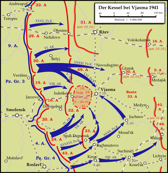
File:Karte - Kesselschlacht bei Vjasma 1941.png

預覽大小:583 × 600 像素。 其他解析度:233 × 240 像素 | 467 × 480 像素 | 747 × 768 像素 | 1,047 × 1,077 像素。
原始檔案 (1,047 × 1,077 像素,檔案大小:338 KB,MIME 類型:image/png)
檔案歷史
點選日期/時間以檢視該時間的檔案版本。
| 日期/時間 | 縮圖 | 尺寸 | 使用者 | 備註 | |
|---|---|---|---|---|---|
| 目前 | 2024年1月13日 (六) 22:19 |  | 1,047 × 1,077(338 KB) | Андрей Романенко | some names and locations corrected |
| 2015年5月31日 (日) 22:01 |  | 1,047 × 1,077(333 KB) | Cmdrjameson | Compressed with pngout. Reduced by 140kB (29% decrease). | |
| 2009年9月13日 (日) 22:53 |  | 1,047 × 1,077(474 KB) | Memnon335bc | {{Information |Description={{en|1=Map showing the Battle near Vyazma (October 2nd — October 20th 1941) during the Second World War (1939—1945) at the Eastern Front. The map is created by Inkscape and is based on the Map 30 in the attachement of the bo |
檔案用途
下列頁面有用到此檔案:
全域檔案使用狀況
以下其他 wiki 使用了這個檔案:
- bg.wikipedia.org 的使用狀況
- de.wikipedia.org 的使用狀況
- en.wikipedia.org 的使用狀況
- es.wikipedia.org 的使用狀況
- et.wikipedia.org 的使用狀況
- fa.wikipedia.org 的使用狀況
- fi.wikipedia.org 的使用狀況
- he.wikipedia.org 的使用狀況
- it.wikipedia.org 的使用狀況
- mn.wikipedia.org 的使用狀況
- nl.wikipedia.org 的使用狀況
- ru.wikipedia.org 的使用狀況
- tr.wikipedia.org 的使用狀況
- uk.wikipedia.org 的使用狀況
- vi.wikipedia.org 的使用狀況
- www.wikidata.org 的使用狀況

