File:Map of Afsluitdijk.png
此為最大尺寸。
Map_of_Afsluitdijk.png (247 × 303 像素,檔案大小:15 KB,MIME 類型:image/png)
摘要
| 描述 |
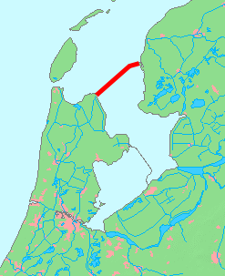
English: Map of Afsluitdijk, Netherlands
日本語: オランダのアフシュライトダイク(締め切り大堤防)の地図 |
| 日期 | |
| 來源 | based on Image:MapNetherlandsWater.PNG |
| 作者 | inoue-hiro |
授權條款
This image is in the public domain because it came from the site https://www.demis.nl/products/web-map-server/examples/ and was released by the copyright holder. Permission is granted to copy, distribute and/or modify this map since it is based on free of copyright images from: www.demis.nl. See also approval email on de.wp and its clarification.
|
| This work has been released into the public domain by its copyright holder, www.demis.nl. This applies worldwide. 這可能在某些國家不合法,如果是的話: www.demis.nl授予任何人有權利使用此作品於任何用途,除受法律約束外,不受任何限制。
|
檔案歷史
點選日期/時間以檢視該時間的檔案版本。
| 日期/時間 | 縮圖 | 尺寸 | 使用者 | 備註 | |
|---|---|---|---|---|---|
| 目前 | 2015年10月9日 (五) 13:29 | | 247 × 303(15 KB) | Io Herodotus | markenwaard removed |
| 2009年2月6日 (五) 12:27 |  | 247 × 303(7 KB) | Inoue-hiro | {{Information |Description={{en|1=Map of Afsluitdijk, Netherlands}} {{ja|1=オランダのアフシュライトダイク(締め切り大堤防)の地図}} |Source=based on Image:MapNetherlandsWater.PNG |Author=inoue-hiro |Date=2009/02/06 |Permiss |
檔案用途
下列頁面有用到此檔案:
全域檔案使用狀況
以下其他 wiki 使用了這個檔案:
- de.wikipedia.org 的使用狀況
- en.wikiversity.org 的使用狀況
- eo.wikipedia.org 的使用狀況
- io.wikipedia.org 的使用狀況
- ja.wikipedia.org 的使用狀況
- vls.wikipedia.org 的使用狀況