File:Map of Hven from copper etching of Blaeu Atlas 1663.jpg
原始檔案 (6,304 × 4,939 像素,檔案大小:19.49 MB,MIME 類型:image/jpeg)
| 描述 |
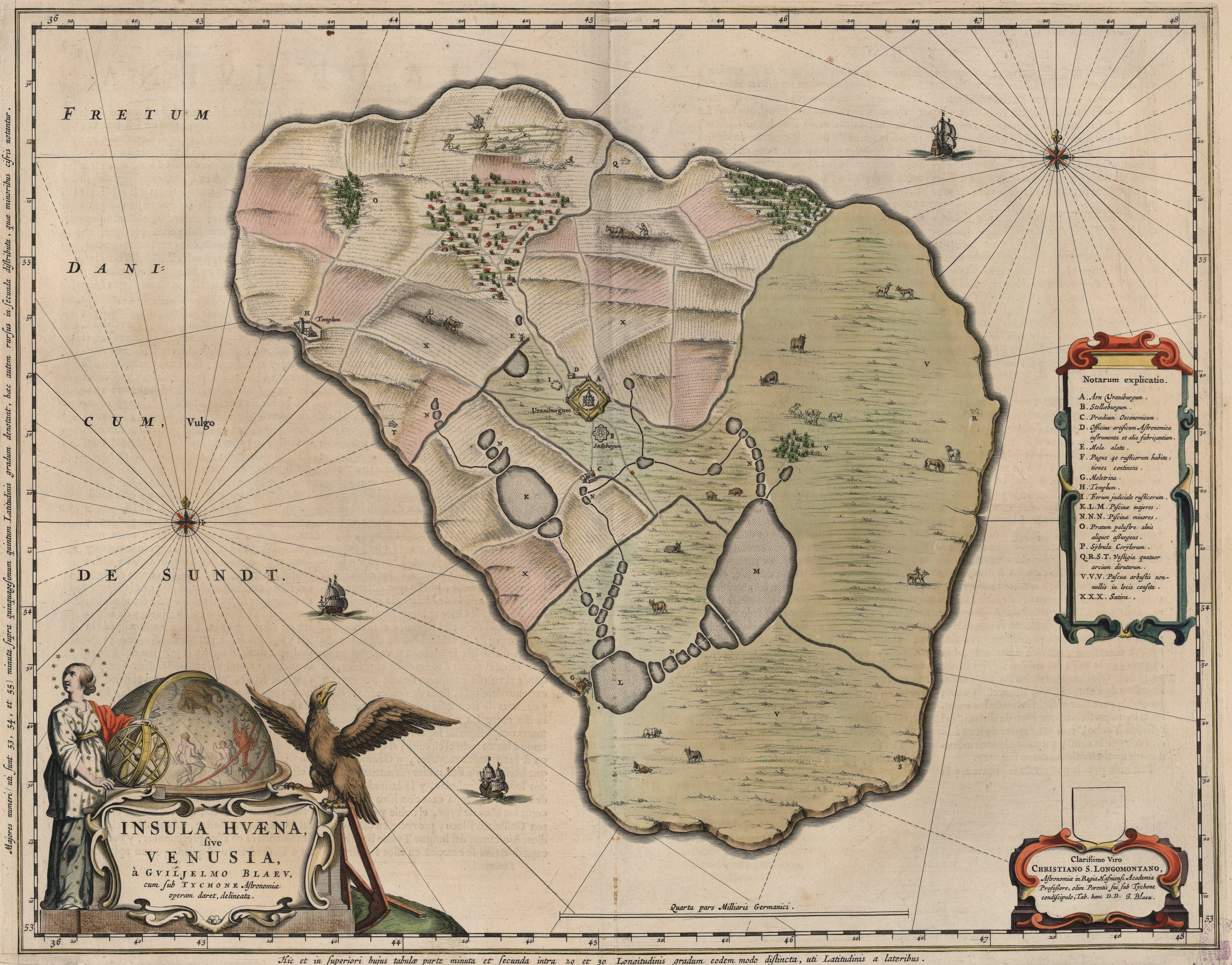
English: Map of the island of Hven from a copper etching of Willem Janszoon Blaeu's Blaeu Atlas 1663.
Willem made this map based on his experience as a student of Tycho Brahe between 1594 and 1596. On this map North is up, Denmark to the west and Scania, now part of Sweden, to the east. It shows the location of Uraniborg just above the centre, and below the linked set of ponds that Tycho had created to both collect water and power his papermill and other small industries on the island. Name of map : INSULAE HVAENA Map record source: Biblioteca Nacionale Espana (click on "View Digital object" to browse from the first page down to "GMG/189/177/mapa") (1664 is date of atlas on title page at "GMG/189/5/hg-ilustracionr") vorige upload: Tychobrahe.com
|
| 日期 | |
| 來源 | (There is no permanent link) Browse to [1], click "View Digital Object", scroll down and click on link "GMG/189/177/mapa", image should appear named "GMG189177mapa.jpeg" in right hand panel. |
| 作者 |
.jpg)
|
本作品在其來源國以及其他著作權期限是作者逝世後100年或以下的國家與地區屬於公有領域。 | |
| 此作品無已知的著作權限制,亦不受所有相關和鄰接的權利限制。 | |
| 註解 | 該圖片含有註解:在維基媒體共享資源上查看註解 |


檔案歷史
點選日期/時間以檢視該時間的檔案版本。
| 日期/時間 | 縮圖 | 尺寸 | 使用者 | 備註 | |
|---|---|---|---|---|---|
| 目前 | 2016年8月9日 (二) 01:06 | | 6,304 × 4,939(19.49 MB) | Centpacrr | crp |
| 2013年1月4日 (五) 11:46 |  | 7,598 × 6,341(5.28 MB) | Joop Rotte | ietwat hogere resolutie | |
| 2005年12月30日 (五) 18:18 |  | 750 × 601(89 KB) | Fred J | :: '' Originally uploaded on English Wikipedia by en:User:Wikibob. Map of the island of Hven from a copper etching of Willem Janszoon Blaeu's Blaeu Atlas 1663. Willem made this map while a student of Tycho Brahe between 1594 and 1596. On th |
檔案用途
下列頁面有用到此檔案:
全域檔案使用狀況
以下其他 wiki 使用了這個檔案:
- de.wikipedia.org 的使用狀況
- en.wikipedia.org 的使用狀況
- et.wikipedia.org 的使用狀況
- fa.wikipedia.org 的使用狀況
- fr.wikipedia.org 的使用狀況
- ia.wikipedia.org 的使用狀況
- ja.wikipedia.org 的使用狀況
- ko.wikipedia.org 的使用狀況
- la.wikipedia.org 的使用狀況
- mk.wikipedia.org 的使用狀況
- nl.wikipedia.org 的使用狀況
- pl.wikipedia.org 的使用狀況
- ru.wikipedia.org 的使用狀況
- sv.wikipedia.org 的使用狀況
- uk.wikipedia.org 的使用狀況