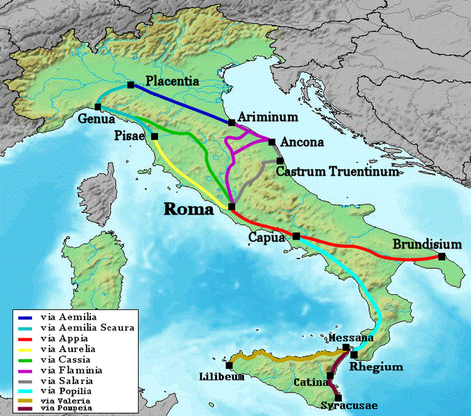
File:Map of Roman roads in Italy.png

預覽大小:679 × 599 像素。 其他解析度:272 × 240 像素 | 544 × 480 像素 | 751 × 663 像素。
原始檔案 (751 × 663 像素,檔案大小:294 KB,MIME 類型:image/png)
檔案歷史
點選日期/時間以檢視該時間的檔案版本。
| 日期/時間 | 縮圖 | 尺寸 | 使用者 | 備註 | |
|---|---|---|---|---|---|
| 目前 | 2012年10月16日 (二) 17:27 |  | 751 × 663(294 KB) | Archeo | why Sicily is not mentioned? |
| 2007年3月2日 (五) 10:59 |  | 751 × 663(303 KB) | Salli~commonswiki | added via Popilia | |
| 2006年1月13日 (五) 01:26 |  | 751 × 663(204 KB) | NielsF | Made this map myself, based upon Image:Map of Italy (w.o. Labels).jpg. Map shows some of the major Roman roads in Italy. Locations not exact. Category:Maps of ItalyCategory:Romans |
檔案用途
全域檔案使用狀況
以下其他 wiki 使用了這個檔案:
- ar.wikipedia.org 的使用狀況
- azb.wikipedia.org 的使用狀況
- be.wikipedia.org 的使用狀況
- bg.wikipedia.org 的使用狀況
- ca.wikipedia.org 的使用狀況
- cs.wikipedia.org 的使用狀況
- cy.wikipedia.org 的使用狀況
- de.wikipedia.org 的使用狀況
- de.wikivoyage.org 的使用狀況
- el.wikipedia.org 的使用狀況
- eml.wikipedia.org 的使用狀況
- en.wikipedia.org 的使用狀況
- es.wikipedia.org 的使用狀況
檢視此檔案的更多全域使用狀況。


