File:Newyork heat island.jpg

預覽大小:298 × 598 像素。 其他解析度:119 × 240 像素 | 540 × 1,084 像素。
原始檔案 (540 × 1,084 像素,檔案大小:149 KB,MIME 類型:image/jpeg)
摘要
| 描述 |
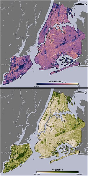
English: Thermal infrared satellite data measured by NASAâs Landsat Enhanced Thematic Mapper Plus on August 14, 2002 one of the hottest days in New York City's summer. Landsat also collected vegetation data. Image from NASA EArth Observatory web page <http://earthobservatory.nasa.gov/Newsroom/NewImages/images.php3?img_id=17354> --Ryanjo 23:43, 1 August 2006 (UTC) |
| 來源 | NASA |
| 作者 | |
| 其他版本 |
 |
授權條款
| 本作品由NASA創作,屬於公有領域。根據NASA的版權政策:“NASA的創作除非另有聲明否則不受版權保護。”(參見:Template:PD-USGov/zh,NASA版權政策或JPL圖像使用政策) | ||
 |
警告:
|
原始上傳日誌
原始描述頁面位於這裡。下列使用者名稱均來自en.wikipedia。
- 2006-08-01 23:43 Ryanjo 540×1084× (152802 bytes) Thermal infrared satellite data measured by NASAâs Landsat Enhanced Thematic Mapper Plus on August 14, 2002 one of the hottest days in New York City's summer. Landsat also collected vegetation data. Image from NASA EArth Observatory web page <http://ear
檔案歷史
點選日期/時間以檢視該時間的檔案版本。
| 日期/時間 | 縮圖 | 尺寸 | 使用者 | 備註 | |
|---|---|---|---|---|---|
| 目前 | 2009年2月23日 (一) 14:49 | | 540 × 1,084(149 KB) | File Upload Bot (Magnus Manske) | {{BotMoveToCommons|en.wikipedia|year={{subst:CURRENTYEAR}}|month={{subst:CURRENTMONTHNAME}}|day={{subst:CURRENTDAY}}}} {{Information |Description={{en|Thermal infrared satellite data measured by NASAâs Landsat Enhanced Thematic Mapper Plus on August |
檔案用途
下列頁面有用到此檔案:
全域檔案使用狀況
以下其他 wiki 使用了這個檔案:
- af.wikipedia.org 的使用狀況
- ca.wikipedia.org 的使用狀況
- da.wikipedia.org 的使用狀況
- en.wikipedia.org 的使用狀況
- eo.wikipedia.org 的使用狀況
- et.wikipedia.org 的使用狀況
- fa.wikipedia.org 的使用狀況
- fr.wikipedia.org 的使用狀況
- fr.wikibooks.org 的使用狀況
- he.wikipedia.org 的使用狀況
- hr.wikipedia.org 的使用狀況
- ja.wikipedia.org 的使用狀況
- ko.wikipedia.org 的使用狀況
- ms.wikipedia.org 的使用狀況
- nn.wikipedia.org 的使用狀況
- ta.wikipedia.org 的使用狀況
- th.wikipedia.org 的使用狀況