File:Rospuda Valley, Poland.jpg

預覽大小:800 × 533 像素。 其他解析度:320 × 213 像素 | 640 × 427 像素 | 1,024 × 683 像素 | 1,280 × 853 像素 | 3,000 × 2,000 像素。
原始檔案 (3,000 × 2,000 像素,檔案大小:3.25 MB,MIME 類型:image/jpeg)
摘要
| 描述 |
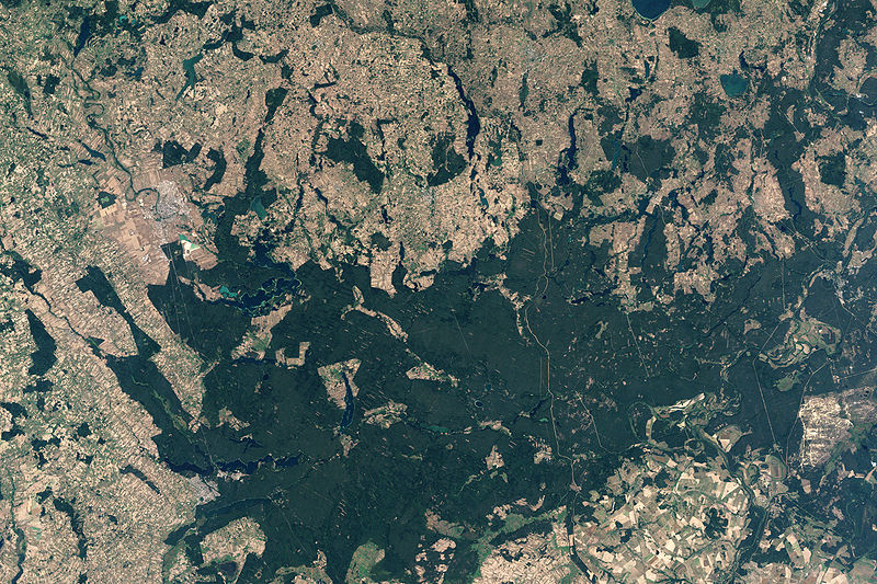
English: NASA’s Landsat 7 satellite captured this image of Rospuda Valley. This true-color image shows a patchwork of peat bog and agricultural fields. In contrast to the nearly uniform deep-green wetlands, the fields appear as close-knit rectangles of varied shades of green and beige. Rospuda River meanders between cultivated fields in the northwest and wetland territory in the southeast, connecting with Lake Necko. Numerous other lakes and ponds appear north and east of Lake Necko, some of them overlapping agricultural areas. |
| 日期 | |
| 來源 | NASA Earth Observatory |
| 作者 | Jesse Allen |
NASA image created by Jesse Allen, using Landsat data provided by the United States Geological Survey.
授權條款
| 本作品由NASA創作,屬於公有領域。根據NASA的版權政策:“NASA的創作除非另有聲明否則不受版權保護。”(參見:Template:PD-USGov/zh,NASA版權政策或JPL圖像使用政策) | ||
 |
警告:
|
檔案歷史
點選日期/時間以檢視該時間的檔案版本。
| 日期/時間 | 縮圖 | 尺寸 | 使用者 | 備註 | |
|---|---|---|---|---|---|
| 目前 | 2009年4月19日 (日) 13:34 | | 3,000 × 2,000(3.25 MB) | Originalwana | {{Information |Description={{en|1=NASA’s Landsat 7 satellite captured this image of Rospuda Valley. This true-color image shows a patchwork of peat bog and agricultural fields. In contrast to the nearly uniform deep-green wetlands, the fields appear as |
檔案用途
下列頁面有用到此檔案:
全域檔案使用狀況
以下其他 wiki 使用了這個檔案:
- en.wikipedia.org 的使用狀況
- ka.wikipedia.org 的使用狀況
- lt.wikipedia.org 的使用狀況
- ru.wikipedia.org 的使用狀況
- uk.wikipedia.org 的使用狀況