File:Victoria crater from HiRise.jpg
原始檔案 (4,045 × 5,085 像素,檔案大小:20.43 MB,MIME 類型:image/jpeg)
摘要
| 描述 |
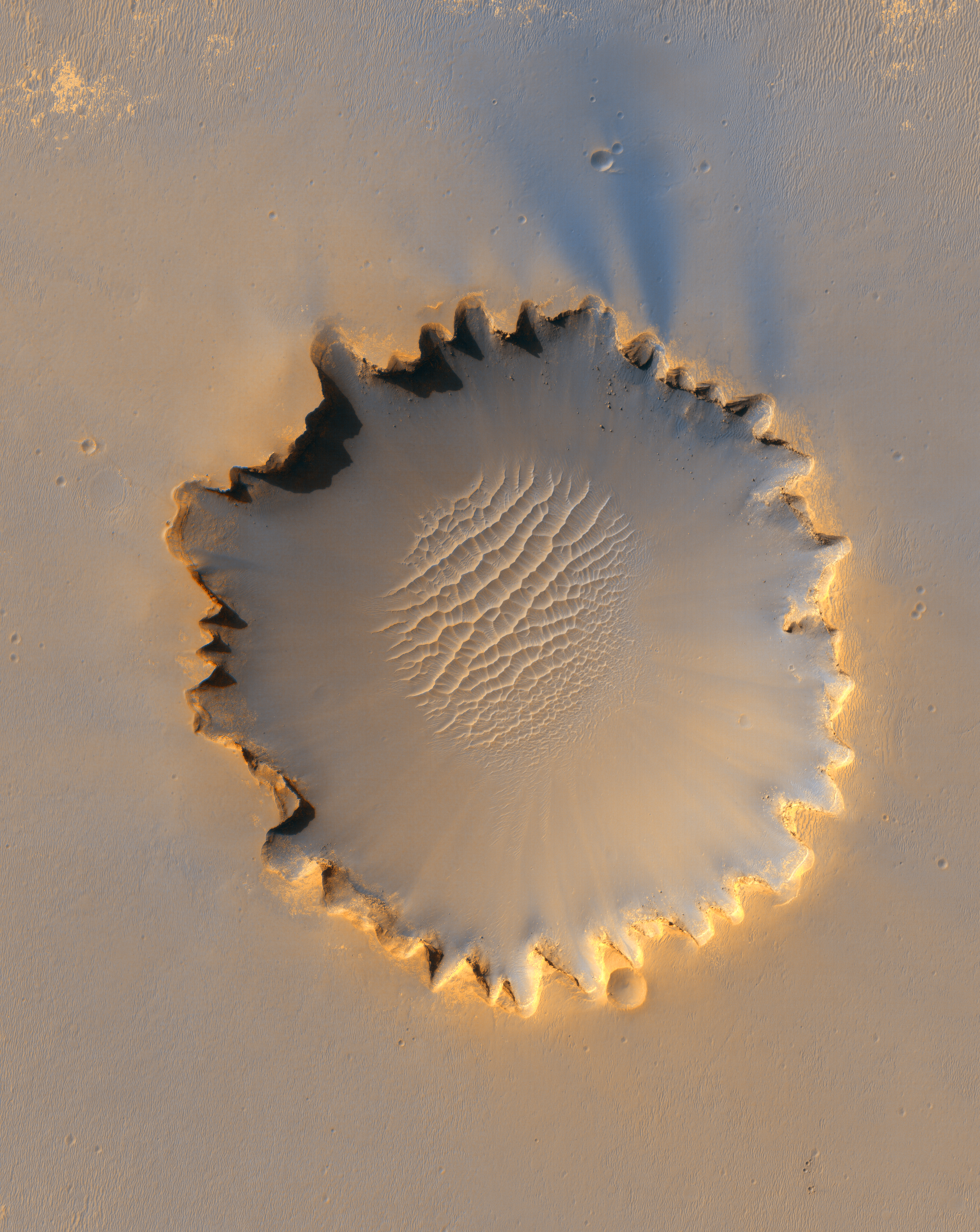
English: This image from the High Resolution Imaging Science Experiment on NASA's Mars Reconnaissance Orbiter shows "Victoria crater," an impact crater at Meridiani Planum, near the equator of Mars. The crater is approximately 800 meters (half a mile) in diameter. It has a distinctive scalloped shape to its rim, caused by erosion and downhill movement of crater wall material. Layered sedimentary rocks are exposed along the inner wall of the crater, and boulders that have fallen from the crater wall are visible on the crater floor. The floor of the crater is occupied by a striking field of sand dunes.
Since January 2004, the Mars Exploration Rover Opportunity has been operating at Meridiani Planum. Five days before this image was taken, Opportunity arrived at the rim of Victoria crater, after a drive of more than 9 kilometers (over 5 miles). The rover can be seen in this image, at roughly the "ten o'clock" position along the rim of the crater. This view is a portion of an image taken by the High Resolution Imaging Science Experiment (HiRISE) camera onboard the Mars Reconnaissance Orbiter spacecraft on Oct. 3, 2006. The complete image is centered at minus7.8 degrees latitude, 279.5 degrees East longitude. The range to the target site was 297 kilometers (185.6 miles). At this distance the image scale is 29.7 centimeters (12 inches) per pixel (with 1 x 1 binning) so objects about 89 centimeters (35 inches) across are resolved. The image shown here has been map-projected to 25 centimeters (10 inches) per pixel and north is up. The image was taken at a local Mars time of 3:30 PM and the scene is illuminated from the west with a solar incidence angle of 59.7 degrees, thus the sun was about 30.3 degrees above the horizon. At a solar longitude of 113.6 degrees, the season on Mars is northern summer. The full-resolution TIFF file (HiRISE number TRA_000873_1780) can be viewed or downloaded here PIA08813-hi-res.tif; the full-resolution JPEG can be viewed or downloaded here PIA08813-hi-res.jpg. |
| 日期 | |
| 來源 | http://photojournal.jpl.nasa.gov/catalog/PIA08813 |
| 作者 | NASA/JPL/University of Arizona |
| 授權許可 (重用此檔案) |
PD |
| 其他版本 |
|


| 描述 |
Български: Това изображение от High Resolution Imaging Science Experiment на Mars Reconnaissance Orbiter на NASA показва кратера Victoria - ударен кратер в равнината Meridiani Planum близо до екватора на Mars. Кратерът е широк приблизително 800 m (половин миля) в диаметър. Има отличителна раковинна форма на ръба си, причинена от ерозиата и свлачищното движение на материала на кратерната стена. Наслоените седиментни скали са изложени по вътрешната стена на кратера, а на дъното на кратера се виждат големи скални блокове, паднали от кратерната стена. Дъното на кратера е покрито с поразително поле от пясъчни дюни.
От януари 2004 г. Mars Exploration Rover Opportunity действа в Meridiani Planum. Пет дни преди да е направена тази снимка, Opportunity пристига на ръба на кратера Виктория, след като е изминал повече от 9 km (над 5 мили). Роувърът може да се види на това изображение на позиция приблизително "10 часа" на ръба на кратера. Този изглед е част от изображение, направено от камерата на High Resolution Imaging Science Experiment (HiRISE) на борда на кораба-спътник Mars Reconnaissance Orbiter на 3 октомври 2006 г. Цялото изображение е центрирано на минус 7,8 градуса ширина, 279,5 градуса източна дължина. Разстоянието до целевия обект е 297 km (185,6 мили). При това разстояние мащабът на изображението е 29,7 cm (12 инча) на пиксел (с матрица 1 x 1 (т.е. пълна резолюция, т.е. без комбиниране (binning) на съседни пиксели)), така че се различават обекти с минимален размер около 89 cm (35 инча). Показаното тук изображение е наложено на равнина (за да се получи плоска карта) от 25 cm (10 инча) на пиксел и север е нагоре. Изображението е направено при местно време на Марс 15:30 ч. и изгледът се осветява от запад с ъгъл на падане на слънчевите лъчи от 59,7 градуса, като по този начин Слънцето е около 30,3 градуса над хоризонта. При слънчева дължина от 113,6 градуса сезонът на Марс е северно лято. TIFF файл с пълна резолюция (HiRISE номер TRA_000873_1780) може да се разгледа или изтегли тук PIA08813-hi-res.tif; JPEG файл с пълна резолюция може да се разгледа или изтегли тук PIA08813-hi-res.jpg. |
| 日期 | |
| 來源 | http://photojournal.jpl.nasa.gov/catalog/PIA08813 |
| 作者 | NASA/JPL/Университет на Аризона |
| 授權許可 (重用此檔案) |
PD |
| 其他版本 |
|
|

| 此標籤不表示文件的著作權狀態。任何文件在附有此標籤的同時還需要一個有效的著作權標籤。請參閱許可協議說明頁面以了解更多資訊。 其他語言:
|
授權條款
| 本作品由NASA創作,屬於公有領域。根據NASA的版權政策:“NASA的創作除非另有聲明否則不受版權保護。”(參見:Template:PD-USGov/zh,NASA版權政策或JPL圖像使用政策) | ||
 |
警告:
|
原始上傳日誌
| date/time | username | resolution | size | edit summary |
|---|---|---|---|---|
| 16:19, 6 October 2006 | User:Yaohua2000 | 4,045×5,085 | 3.03 MB | Victoria crater |
| 註解 | 該圖片含有註解:在維基媒體共享資源上查看註解 |
檔案歷史
點選日期/時間以檢視該時間的檔案版本。
| 日期/時間 | 縮圖 | 尺寸 | 使用者 | 備註 | |
|---|---|---|---|---|---|
| 目前 | 2020年5月9日 (六) 20:13 | | 4,045 × 5,085(20.43 MB) | Cmao20 | Upload at higher quality compression (Photoshop 12) from original TIFF |
| 2008年6月13日 (五) 13:12 |  | 4,045 × 5,085(3.03 MB) | BetacommandBot | move approved by: User:TheDJ This image was moved from Image:PIA08813.jpg {{Assessments|dewiki=1|enwiki=1|trwiki=1}} == Summary == {{Information |Description=This image from the High Resolution Imaging Science Experiment on NASA's [[Mar |
檔案用途
下列9個頁面有用到此檔案:
全域檔案使用狀況
以下其他 wiki 使用了這個檔案:
- af.wikipedia.org 的使用狀況
- ar.wikipedia.org 的使用狀況
- ast.wikipedia.org 的使用狀況
- bn.wikipedia.org 的使用狀況
- bn.wikibooks.org 的使用狀況
- ce.wikipedia.org 的使用狀況
- da.wikipedia.org 的使用狀況
- de.wikipedia.org 的使用狀況
- dsb.wikipedia.org 的使用狀況
- en.wikipedia.org 的使用狀況
- Mars Reconnaissance Orbiter
- Victoria (crater)
- Wikipedia:Featured pictures thumbs/04
- Wikipedia:WikiProject Astronomy/Mars task force
- Portal:Outer space/Featured
- User:Cody.pope
- Wikipedia:Featured picture candidates/October-2006
- Wikipedia:Featured picture candidates/VictoriaCrater
- Wikipedia:Wikipedia Signpost/2006-10-23/Features and admins
- Wikipedia:Picture of the day/January 2007
- Portal:Outer space/Featured/Picture
- Wikipedia:Wikipedia Signpost/2006-10-23/SPV
- Template:POTD/2007-01-14
- User:Holly Cheng/Picture of the day/January 2007
- Wikipedia:Picture of the day/January 14, 2007
- Wikipedia:WikiProject Astronomy/Recognized content
- Portal:Solar System/Selected picture
- Portal:Solar System/Selected picture/12
- User:Ceranthor/CV
- User:Ceranthor/editnotice
- Wikipedia:Featured pictures/Space/Looking out
- Wikipedia:WikiProject Astronomy/Recognized astronomy content
- Wikipedia:WikiProject Astronomy/Mars task force/Recognized content
- Timeline of Opportunity
- User:Kmend1/sandbox
- User:JPxG/SP 2006-2010
- Wikipedia:Wikipedia Signpost/Single/2006-10-23
檢視此檔案的更多全域使用狀況。