File:Ursprung der Farben des Deutschen Reichs.png

原始文件 (3,000 × 3,000像素,文件大小:1.22 MB,MIME类型:image/png


摘要

描述
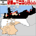
Deutsch: Die Karte zeigt den Ursprung der Farben des Deutschen Reichs beziehungsweise des Norddeutschen Bunds. Preußen ist in seinen Landesfarben schwarz-weiß eingefärbt. Eine Auswahl wichtiger Hansestädte mit roter oder rot-weißer Flagge wurde in die Karte eingezeichnet. Über der Karte befindet sich eine Legende (Zeichenerklärung). Die Karte zeigt, dass die Reichsflagge Schwarz-Weiß-Rot nicht alle Deutschen repräsentiert, da sie eine Dominanz Norddeutschlands impliziert.
English: The map shows the origin of the colors of the German Reich or the North German Confederation. Prussia is dyed black and white in its country colors. A selection of important Hanseatic cities with red or red-white flags was drawn into the map. Above the map is ist cartographic symbology. The map shows that the colors black-white-red do not represent all Germans, because they imply a dominance of Northern Germany.
日期
来源

Based on: https://commons.wikimedia.org/wiki/File:Map-DR-Prussia.svg

English: Based on map data of the IEG-Maps project (Andreas Kunz, B. Johnen and Joachim Robert Moeschl: University of Mainz) — http://www.ieg-maps.uni-mainz.de

Русский: Основано на карте проекта IEG-Maps (Андреас Кунц, Б. Йонен и Йоахим Роберт Моешль: Университет Майнца) — http://www.ieg-maps.uni-mainz.de
作者 M. Nauerz

许可协议

w:zh:知识共享
署名 相同方式共享
本文件采用知识共享署名-相同方式共享 2.5 通用许可协议授权。
您可以自由地:
  • 共享 – 复制、发行并传播本作品
  • 修改 – 改编作品
惟须遵守下列条件:
  • 署名 – 您必须对作品进行署名,提供授权条款的链接,并说明是否对原始内容进行了更改。您可以用任何合理的方式来署名,但不得以任何方式表明许可人认可您或您的使用。
  • 相同方式共享 – 如果您再混合、转换或者基于本作品进行创作,您必须以与原先许可协议相同或相兼容的许可协议分发您贡献的作品。

说明

添加一行文字以描述该文件所表现的内容
The map shows the origin of the colors of the German Reich (Prussia and Hanseatic cities)

文件历史

点击某个日期/时间查看对应时刻的文件。

日期/时间缩⁠略⁠图大小用户备注
当前2019年9月24日 (二) 23:352019年9月24日 (二) 23:35版本的缩略图3,000 × 3,000(1.22 MB)Wissen der MenschheitUser created page with UploadWizard

以下页面使用本文件:

全域文件用途

以下其他wiki使用此文件:

元数据