File:Wales Administration Map 1947.png

本预览的尺寸:373 × 598像素。 其他分辨率:149 × 240像素 | 299 × 480像素 | 478 × 768像素 | 638 × 1,024像素 | 2,250 × 3,610像素。
原始文件 (2,250 × 3,610像素,文件大小:1.79 MB,MIME类型:image/png)
| 描述 |
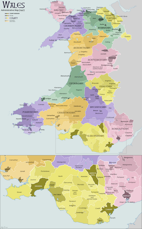
English: Map showing the administrative counties and other sub-divisions of Wales in 1947 |
| 日期 | |
| 来源 | 自己的作品 |
| 作者 | XrysD |
我,本作品著作权人,特此采用以下许可协议发表本作品:

|
已授权您依据自由软件基金会发行的无固定段落及封面封底文字(Invariant Sections, Front-Cover Texts, and Back-Cover Texts)的GNU自由文件许可协议1.2版或任意后续版本的条款,复制、传播和/或修改本文件。该协议的副本请见“GNU Free Documentation License”。 |
文件历史
点击某个日期/时间查看对应时刻的文件。
| 日期/时间 | 缩略图 | 大小 | 用户 | 备注 | |
|---|---|---|---|---|---|
| 当前 | 2012年11月10日 (六) 09:48 | | 2,250 × 3,610(1.79 MB) | XrysD | Fixed typo, Bethseda->Bethesda |
| 2010年2月22日 (一) 21:37 |  | 2,250 × 3,610(1.79 MB) | XrysD | Moved St Asaph from Denbigh to Flint. | |
| 2009年10月31日 (六) 19:15 |  | 2,250 × 3,610(1.8 MB) | XrysD | {{Information |Description={{en|1=Map showing the administrative counties and other sub-divisions of Wales in 1947}} |Source={{own}} |Author=XrysD |Date=2009-10-31 |Permission= |other_versions= }} {{self|GFDL}} |
文件用途
以下页面使用本文件:
全域文件用途
以下其他wiki使用此文件:
- cy.wikipedia.org上的用途
- en.wikipedia.org上的用途
- List of rural and urban districts in Wales in 1973
- History of local government in Wales
- 1949 United Kingdom local elections
- 1934 United Kingdom local elections
- Ammanford Urban District Council
- Burry Port Urban District
- Llandeilo Urban District
- 1955 United Kingdom local elections
- Llandeilo Rural District
- Carmarthen Rural District
- Municipal Borough of Llanelly
- Template:Carmarthenshire Pre-1974
- Carmarthen Borough Council
- Whitland Rural District
- fr.wikipedia.org上的用途
- uz.wikipedia.org上的用途