卡利斯佩尔
美国蒙大拿州城市
(重定向自卡利斯佩尔 (蒙大拿州))
卡利斯佩尔(英语:Kalispell,西班牙语:qlispél[4][5])位于美国蒙大拿州西北部,是弗拉特黑德县的县治所在。[6]根据2000年人口普查,本城共有人口14,223人。[6]这个数字于2010年上升至17,396。[7]而2011年人口估计则显示本城共有人口20,008人。[8] 卡利斯佩尔是蒙大拿州西北部最大城市。[9][10]
| 卡利斯佩尔 Kalispell | |
|---|---|
| 城市 | |
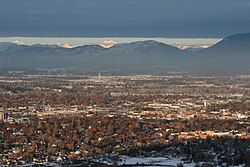
 远眺卡利斯佩尔 | |
 卡利斯佩尔在蒙大拿州的位置 | |
| 坐标:48°12′N 114°19′W / 48.2°N 114.32°W | |
| 国家 | 美国 |
| 州 | 蒙大拿州 |
| 县 | 弗拉特黑德县 |
| 政府 | |
| • 市长 | 悉尼·史塔里希 |
| 面积[1] | |
| • 城市 | 11.73 平方英里(30.38 平方公里) |
| • 陆地 | 11.64 平方英里(30.15 平方公里) |
| • 水域 | 0.09 平方英里(0.23 平方公里) |
| 海拔 | 2,956 英尺(901 米) |
| 人口(2010年)[2] | |
| • 城市 | 19,927人 |
| • 估计(2012[3]) | 20,487 |
| • 密度 | 1,711.9人/平方英里(661.0人/平方公里) |
| • 都会区 | 91,633 |
| 时区 | 北美山区时区(UTC-7) |
| • 夏时制 | 北美山区时区(UTC-6) |
| ZIP代码 | 59901-59904 |
| 电话区号 | 406 |
| FIPS代码 | 30-40075 |
| GNIS代码 | 0785622 |
| 网站 | Official city website |
地理
编辑卡利斯佩尔的座标为48°11′52″N 114°18′58″W / 48.19778°N 114.31611°W(48.197801,-114.316068)。[11]根据2000年人口普查,本城面积为11.73平方英里(30.38平方千米),其中11.64平方英里(30.15平方千米)为陆地,0.09平方英里(0.23平方千米)为水域。[1]
气候
编辑卡利斯佩尔拥有湿润大陆性气候。
| 卡利斯佩尔 | |||||||||||||
|---|---|---|---|---|---|---|---|---|---|---|---|---|---|
| 月份 | 1月 | 2月 | 3月 | 4月 | 5月 | 6月 | 7月 | 8月 | 9月 | 10月 | 11月 | 12月 | 全年 |
| 历史最高温 °F(°C) | 56 (13) |
64 (18) |
73 (23) |
85 (29) |
95 (35) |
96 (36) |
104 (40) |
105 (41) |
99 (37) |
86 (30) |
69 (21) |
58 (14) |
105 (41) |
| 平均高温 °F(°C) | 31.2 (−0.4) |
36.0 (2.2) |
45.6 (7.6) |
56.1 (13.4) |
65.1 (18.4) |
72.0 (22.2) |
81.4 (27.4) |
81.4 (27.4) |
69.9 (21.1) |
54.9 (12.7) |
39.6 (4.2) |
29.7 (−1.3) |
55.2 (12.9) |
| 平均低温 °F(°C) | 16.4 (−8.7) |
18.2 (−7.7) |
25.1 (−3.8) |
31.2 (−0.4) |
38.5 (3.6) |
44.5 (6.9) |
48.0 (8.9) |
46.5 (8.1) |
38.4 (3.6) |
29.4 (−1.4) |
24.0 (−4.4) |
15.8 (−9.0) |
31.3 (−0.4) |
| 历史最低温 °F(°C) | −38 (−39) |
−36 (−38) |
−29 (−34) |
−8 (−22) |
17 (−8) |
26 (−3) |
30 (−1) |
30 (−1) |
7 (−14) |
−4 (−20) |
−28 (−33) |
−35 (−37) |
−38 (−39) |
| 平均降水量 英寸(mm) | 1.33 (34) |
.96 (24) |
1.08 (27) |
1.24 (31) |
1.97 (50) |
2.56 (65) |
1.44 (37) |
.99 (25) |
1.39 (35) |
1.01 (26) |
1.42 (36) |
1.60 (41) |
17.00 (432) |
| 平均降雪量 英寸(cm) | 13.4 (34) |
8.5 (22) |
5.7 (14) |
1.9 (4.8) |
.2 (0.51) |
.3 (0.76) |
0 (0) |
0 (0) |
0 (0) |
1.0 (2.5) |
8.9 (23) |
15.7 (40) |
55.8 (142) |
| 平均降水天数(≥ 0.01 in) | 13.7 | 10.8 | 11.8 | 10.7 | 12.4 | 12.5 | 7.7 | 7.3 | 8.2 | 9.3 | 13.0 | 14.4 | 131.8 |
| 平均降雪天数(≥ 0.1 in) | 10.5 | 7.8 | 5.0 | 2.5 | .3 | .1 | 0 | 0 | 0 | 1.2 | 7.1 | 11.1 | 45.6 |
| 数据来源:NOAA (extremes 1899–present),[12] The Weather Channel [13] | |||||||||||||
参考文献
编辑- ^ 1.0 1.1 US Gazetteer files 2010. United States Census Bureau. [2012-12-18]. (原始内容存档于2012-07-14).
- ^ American FactFinder. United States Census Bureau. [2013-01-25]. (原始内容存档于2012-02-17).
- ^ Population Estimates. United States Census Bureau. [2013-06-03]. (原始内容存档于2013-06-17).
- ^ FirstVoices: Nature / Environment - place names: words. Ktunaxa.. [2012-07-07]. (原始内容存档于2013-01-16).
- ^ Tachini, Pete; Louie Adams, Sophie Mays, Mary Lucy Parker, Johnny Arlee, Frances Vanderburg, Lucy Vanderburg, Diana Christopher-Cote. nyoʻnuntn q̓éymin, Flathead Nation Salish dictionary. Pablo, Montana: Bilingual Education Department, Salish Kootenai College. 1998: 75.
- ^ 6.0 6.1 American FactFinder. United States Census Bureau. [2008-01-31].
- ^ 2010 census factfinder2. [2013-07-30]. (原始内容存档于2013-09-11).
- ^ Kalispell (city) QuickFacts from the US Census Bureau. [2013-07-30]. (原始内容存档于2013-12-20).
- ^ 存档副本. [2013-07-30]. (原始内容存档于2013-04-01).
- ^ Flathead County QuickFacts from the US Census Bureau. [2013-07-30]. (原始内容存档于2011-07-10).
- ^ US Gazetteer files: 2010, 2000, and 1990. United States Census Bureau. 2011-02-12 [2011-04-23].
- ^ NowData - NOAA Online Weather Data. National Oceanic and Atmospheric Administration. [2013-06-24]. (原始内容存档于2014-07-24).
- ^ Monthly Averages for Kalispell, MT. The Weather Channel. [January 15, 2011]. (原始内容存档于2012-10-23).