安德森县 (得克萨斯州)
安德森县(英语:Anderson County)是美国德克萨斯州东部的一个县。面积2,792平方公里。根据2010年人口普查,共有人口55,109人。[1]根据2010年人口普查,共有人口58,458人。[2]>县治巴勒斯坦(Palestine)。[3]
| 安德森县 Anderson County | |
|---|---|
| 县 | |
 位于帕勒斯坦的县法院 | |
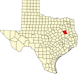
 安德森县于德克萨斯州中的位置 | |
 德克萨斯州于美国的位置 | |
| 坐标:31°49′N 95°39′W / 31.81°N 95.65°W | |
| 国家 | |
| 州 | |
| 设立日期 | 1846年3月24日 |
| 语源 | 肯尼斯·刘易斯·安德森 |
| 县治 | 帕勒斯坦 |
| 最大城市 | 帕勒斯坦 |
| 面积 | |
| • 总计 | 1,078 平方英里(3,000 平方公里) |
| • 陆地 | 1,063 平方英里(3,000 平方公里) |
| • 水域 | 15 平方英里(40 平方公里) 1.4% |
| 人口(2020年) | |
| • 总计 | 57,922人 |
| 时区 | 中部时区(UTC−6) |
| • 夏时制 | 中部时区(UTC−5) |
| 包含的国会选区 | 第五国会选区 |
| 网站 | www |
成立于1846年3月24日。县名纪念德克萨斯共和国最后一任副总统K·L·安德森(Kenneth Lewis Anderson)。[4][5]
地理
编辑根据2000年人口普查,安德森县的总面积为1,078平方英里(2,790平方千米),其中有1,071平方英里(2,770平方千米),即99.34%为陆地;7平方英里(18平方千米),即0.66%为水域。[6]
毗邻县
编辑所有安德森县的毗邻县皆为德克萨斯州的县份
国家保护区
编辑- 内奇斯河国家野生动物保护区(部分)
人口
编辑| 调查年 | 人口 | 备注 | %± |
|---|---|---|---|
| 1850 | 2,684 | — | |
| 1860 | 10,398 | 287.4% | |
| 1870 | 9,229 | −11.2% | |
| 1880 | 17,395 | 88.5% | |
| 1890 | 20,923 | 20.3% | |
| 1900 | 28,015 | 33.9% | |
| 1910 | 29,650 | 5.8% | |
| 1920 | 34,318 | 15.7% | |
| 1930 | 34,643 | 0.9% | |
| 1940 | 37,092 | 7.1% | |
| 1950 | 31,875 | −14.1% | |
| 1960 | 28,162 | −11.6% | |
| 1970 | 27,789 | −1.3% | |
| 1980 | 38,381 | 38.1% | |
| 1990 | 48,024 | 25.1% | |
| 2000 | 55,109 | 14.8% | |
| 2010 | 58,458 | 6.1% | |
| [7][8][9] | |||
根据2000年人口普查[1],安德森县拥有55,109居民、15,678住户和11,335家庭。[10]其人口密度为每平方英里52居民(每平方公里20居民)。[11]本县拥有18,436间房屋单位,其密度为每平方英里17间(每平方公里7间)。[12]
参考文献
编辑- ^ 1.0 1.1 American FactFinder. United States Census Bureau. [2008-01-31].
- ^ 2010 census factfinder2. [2013-08-08]. (原始内容存档于2013-09-11).
- ^ Find a County. National Association of Counties. [2011-06-07].
- ^ 德克薩斯百科全書. [2016-03-24]. (原始内容存档于2020-08-19).
- ^ US Board on Geographic Names. United States Geological Survey. 2007-10-25 [2008-01-31].
- ^ Census 2000 U.S. Gazetteer Files: Counties. United States Census. [2011-02-13]. (原始内容存档于2012-06-06).
- ^ 1900-1990 census data. United States Census Bureau. [2013-05-06]. (原始内容存档于2013-06-18).
- ^ American FactFinder. Factfinder2.census.gov. [2013-02-16]. (原始内容存档于2013-09-11).
- ^ University of Virginia Library. Mapserver.lib.virginia.edu. [2013-02-16]. (原始内容存档于2012-08-11).
- ^ (英文)Population Profile of the United States: 2000 (页面存档备份,存于互联网档案馆)
- ^ Statistical profile of Alger County, Michigan (页面存档备份,存于互联网档案馆), United States Census Bureau, Census 2000
- ^ (英文)State and County QuickFacts (页面存档备份,存于互联网档案馆)