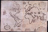
墨卡托世界地图 (1569年)
1569年墨卡托世界地图标题为“Nova et Aucta Orbis Terrae Descriptio ad Usum Navigantium Emendate Accommodata ”(文艺复兴时期的拉丁文,意思是“适用于导航且更完整的全新地球仪”)。标题表明格拉杜斯·墨卡托想要展示当代世界的地理知识,以及“修正”图表使其变得对水手更实用。他的“修正”方式是将球体上的恒定方位航线(恒向线)映射到平面图上的直线,这是墨卡托投影法的特征。虽然该地图的地理信息已被现代知识所取代,但这种投影被证明是在地图制作史上的里程碑,这启发地图历史学家诺登舍尔德写道:“自托勒密之后,地图制作史上无人能及鲁佩尔蒙德的大师”[2]。墨卡托投影法预示著导航图表进入新时代,而之后的基础仍旧会是墨卡托投影法。

地图上注记了大量的文字,带框线的地图图例(或称漩涡装饰)涵盖了各种主题,包括对赞助者的致谢词以及版权声明;关于经线、大圆和距离的讨论;对一些主要河流的评论;关于北极和南部大陆地理的虚构资讯。其它次要文本则散布在地图上,涵盖了磁极、本初子午线、航海特色、次要地理细节、发现之旅、巨人和食人族传说等主题。
与1569年之前的世界地图的相比可看出,墨卡托借鉴了其他制图师以及他自己从前的作品,但他宣称很大程度上也参考了葡萄牙和西班牙水手的波特兰型海图。早期的世界地图制图师大多忽略了水手们更准确的实用航海图,反之亦然,但是从15世纪最后十年开始的大发现时代促进这两种传统制图技法的整合,墨卡托世界地图即为此次合并的早期成果 。

1569年之前的世界地图和区域地图
编辑文艺复兴时期在1569年之前的世界地图—不同投影

.jpg)


![奥特柳斯 (Ortelius),1570[3]](/wiki/File:OrteliusWorldMap.jpeg)


1569年墨卡托地图的主要特征
编辑墨卡托投影
编辑._HM_46._PORTOLAN_ATLAS_and_NAUTICAL_ALMANAC._France,_1543.jpg)
第一批使用墨卡托投影的地图
-
 1597,洪第乌斯;基督教骑士地图
 -
 莱特亚述尔群岛航行图(Wright Azores sailing map),1599
 -
 Wright-Moxon版世界地图,1657
 -
 Blaeú地图集,1606及后续版本


.jpg)


装饰特色
编辑


收藏册和地图收藏
编辑- Barron, Roderick, Decorative Maps, Londo: Studio Editions, 1989, ISBN 978-1851702985
- Baynton-Williams, Ashley and Miles, New Worlds: maps from the age of discovery, London: Quercus, 2006, ISBN 978-1905204809
- Mercator, Atlas of Europe, 1570. 大英图书馆有两个线上版本:“翻页版”在 [1] (页面存档备份,存于互联网档案馆) ,带注释的副本在[2] (页面存档备份,存于互联网档案馆).
- Nordenskiöld, Adolf Eric, Periplus : An essay on the early history of charts and sailing-direction translated from the Swedish original by Francis A. Bather. With reproductions of old charts and maps., Stockholm, 1897
- Nordenskiöld, Adolf Eric, Facsimile-atlas till kartografiens äldsta historia English [Facsimile-atlas to the early history of cartography with reproductions of the most important maps printed in the XV and XVI centuries translated from the Swedish by J. A. Ekelöf and C. R. Markham], Kraus Reprint Corporation and New York Dover Publications London Constable 1973, 1889, ISBN 978-0486229645
- Shirley, Rodney W., The mapping of the world : early printed world maps 1472-1700 4, Riverside, Conn.: Early World Press, 2001, ISBN 978-0970351807
- Ptolemy, Claudius, Cosmography, Leicester: Magna, 1990, ISBN 978-1854221032. 15世纪手稿《Codex Lat V F.32》的地图在那不勒斯国家图书馆。
1569年之前的世界地图
编辑- de la Cosa, Juan, Map of Juan de la Cosa, 1500 Nordenskiöld Periplus, plate XLIII.
- Ribero, Diego, The second Borgian map by Diego Riber, 1529 Nordenskiöld plates XLVIII-XLIX .
- Gastaldi, Giacomo, Universale, 1546 Müller-Baden, Emanuel (Hrsg.): Bibliothek des allgemeinen und praktischen Wissens, Bd. 2. – Berlin, Leipzig, Wien, Stuttgart: Deutsches Verlaghaus Bong & Co, 1904. – 1. Aufl.
- Mercator, Gerardus, 1538 Mercator Map, 1538 Nordenskiöld Facsimile Atlas, plate XLIII. Shirley plate 79 (entries 74 and 91).
- Ortelius, Abraham, Nova Totius Terrarum Orbis, 1564 Shirley plate 97 (entry 114).
1569年之前的区域地图
编辑- Mercator, Gerardus, Map of Europe, 1554.
- Gastaldi, Map of Asia, 1561 Nordenskiöld Periplus, plates LIV, LV, LVI.
- Gastaldi, Map of Africa, 1564 Nordenskiöld Periplus, plates XLVI.
- Gutierez, Map of South America, 1562 Bagrow, Plate 86.
1569年后使用墨卡托投影的世界地图
编辑- Hondius, Jodocus, The Christian Knight Map, 1597
- Wright, Map for sailing to the Isles of Azores, 1599
- Wright, Edward; Moxon, Joseph, A Plat of All the World, 1655
- Blaeu, William Janzoon, Nova Totius Terrarum Orbis Geographica ac Hydrographiva Tabula, 1606. Printed in New Worlds, page 59
参见
编辑参考文献
编辑
- ^ This portrait appears in the 1596 version of his Atlas It was made in 1574, when Mercator was 62, by the engraver Frans Hogenberg who contributed many of the topographical images in Civitates Orbis Terrarum. See the German wikipedia and commons.
- ^ Nordenskiöld Facsimile Atlas, p.23
- ^ The Ortelius map was published in 1570 but it was known to Mercator from about 1556[来源请求]
_007.jpg)