File:Alsace Lorraine departments evolution map-fr.svg

此SVG文件的PNG预览的大小:600 × 450像素。 其他分辨率:320 × 240像素 | 640 × 480像素 | 1,024 × 768像素 | 1,280 × 960像素 | 2,560 × 1,920像素。
原始文件 (SVG文件,尺寸为600 × 450像素,文件大小:98 KB)
摘要
| 描述 |
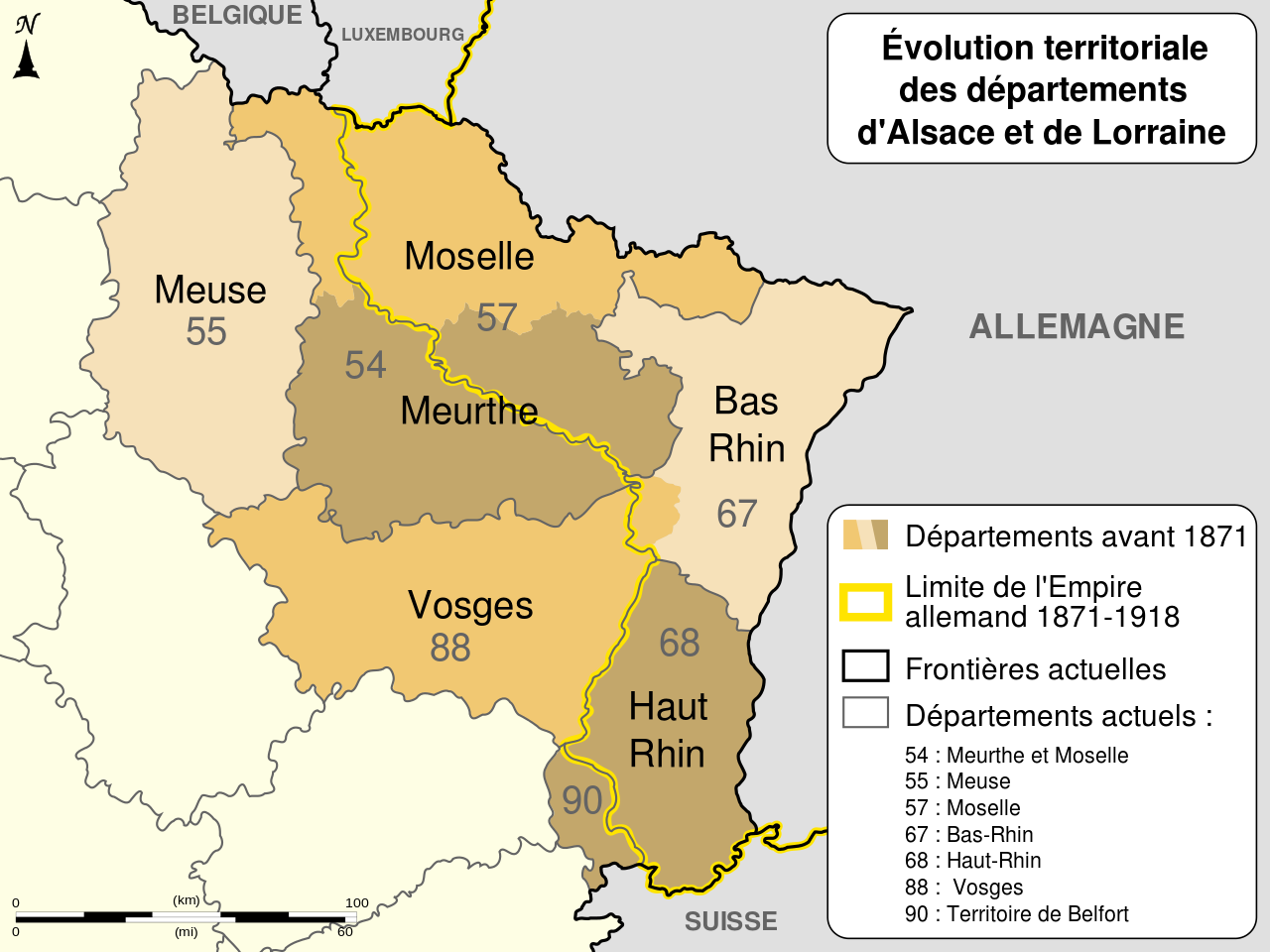
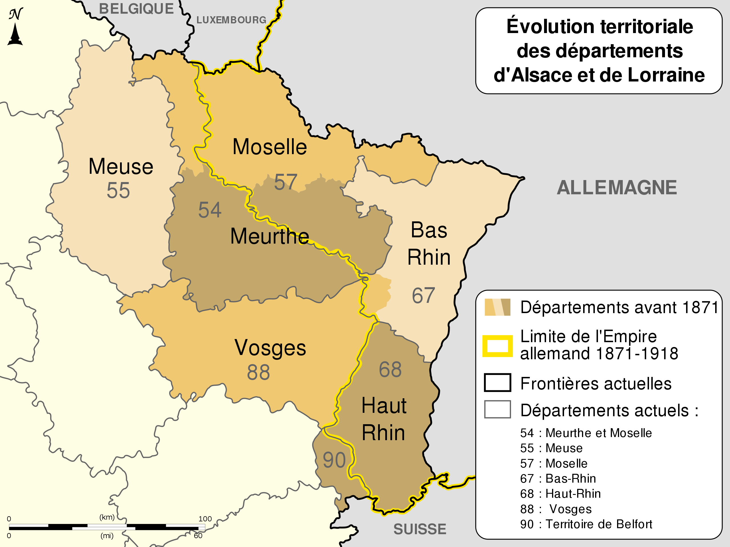
English: Changes of the boundaries of departments in Alsace and Lorraine before and after the German Empire's rule (1871-1918). Français : Évolution territoriale des départements de l'Alsace et de la Lorraine avant et après l'Empire allemand (1871-1918). |
||
| 日期 | (UTC) | ||
| 来源 |
自己的作品. Source :
|
||
| 作者 | Sémhur (talk) | ||
| 其他版本 |
[]
Derivative works of this file: | ||
| 署名 (由许可协议要求) | © Sémhur / Wikimedia Commons / | ||
| SVG | W3C-validity not checked.
|
||
| Graphic Lab |


.svg)
| 相机位置 | | 在以下服务上查看本图像和附近其他图像: OpenStreetMap |
|---|
许可协议
我,本作品著作权人,特此采用以下许可协议发表本作品:
| 非营利著作权:本艺术作品是自由的,您可以依据自由艺术作品许可协议的条款传播和/或修改本艺术作品。您可以在Copyleft Attitude网站或其他网站找到该许可协议的样本。 |
This file is licensed under the Creative Commons Attribution-Share Alike 4.0 International, 3.0 Unported, 2.5 Generic, 2.0 Generic and 1.0 Generic license.
- 您可以自由地:
- 共享 – 复制、发行并传播本作品
- 修改 – 改编作品
- 惟须遵守下列条件:
- 署名 – 您必须对作品进行署名,提供授权条款的链接,并说明是否对原始内容进行了更改。您可以用任何合理的方式来署名,但不得以任何方式表明许可人认可您或您的使用。
- 相同方式共享 – 如果您再混合、转换或者基于本作品进行创作,您必须以与原先许可协议相同或相兼容的许可协议分发您贡献的作品。
您可以选择您需要的许可协议。
文件历史
点击某个日期/时间查看对应时刻的文件。
| 日期/时间 | 缩略图 | 大小 | 用户 | 备注 | |
|---|---|---|---|---|---|
| 当前 | 2013年7月14日 (日) 03:11 | | 600 × 450(98 KB) | Citypeek | Corrected two mistakes. Valid SVG now. |
| 2010年12月27日 (一) 08:17 |  | 600 × 450(98 KB) | Sémhur | Mistake (Moselle) : 56 => 57 | |
| 2010年12月23日 (四) 17:48 |  | 600 × 450(98 KB) | Sémhur | == {{int:filedesc}} == {{Information |Description={{Multilingual description |en= Boundaries evolution of Alsace and Lorraine's departments before and after German Empire (1871-1918). |fr= Évolution territori |
文件用途
全域文件用途
以下其他wiki使用此文件:
- br.wikipedia.org上的用途
- ca.wikipedia.org上的用途
- cs.wikipedia.org上的用途
- de.wikipedia.org上的用途
- el.wikipedia.org上的用途
- eo.wikipedia.org上的用途
- fr.wikipedia.org上的用途
- Bas-Rhin
- Département français
- Haut-Rhin
- Lorraine
- Meurthe-et-Moselle
- Moselle (département)
- Territoire de Belfort
- Meurthe (département)
- Histoire de la Lorraine
- Alsace-Lorraine
- Droit local en Alsace et en Moselle
- Alsace-Moselle
- Histoire des départements français
- Grandfontaine (Bas-Rhin)
- Bidépartementalisation
- Portail:Lorraine/Photographie-05
- Portail:Lorraine/Photographie-0510
- Site des trois bornes
- Politique dans la Moselle
- Wikipédia:Atelier graphique/Cartes/Archives/décembre 2010
- Wikipédia:Atelier graphique/Cartes/Archives/novembre 2011
- Discussion:Deuxième République (France)/Article de qualité
- Histoire de la Moselle
- Wikipédia:Atelier graphique/Cartes/Archives/janvier 2015
- 1871 en Lorraine
- Wikipédia:Le Bistro/29 avril 2017
- Histoire de Meurthe-et-Moselle
- fr.wiktionary.org上的用途
- it.wikipedia.org上的用途
- ja.wikipedia.org上的用途