File:NASA Manhattan.jpg

本预览的尺寸:253 × 599像素。 其他分辨率:101 × 240像素 | 604 × 1,431像素。
原始文件 (604 × 1,431像素,文件大小:599 KB,MIME类型:image/jpeg)
摘要
| 描述 |
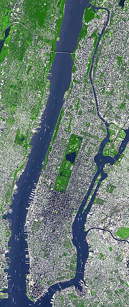
English: This false-color satellite image shows Manhattan, with Queens and Brookyn to the south east and New Jersey to the west. Central Park is visible in the center. This false-color image was acquired on Sept. 8, 2002, by the Advanced Spaceborne Thermal Emission and Reflection Radiometer (ASTER) aboard NASA's Terra satellite. Vegetated land surface is green, paved urban areas are a whitish blue, and water is dark blue. Image cropped by the uploader on 5 August 2006. |
| 日期 | |
| 来源 | http://earthobservatory.nasa.gov/Newsroom/NewImages/images.php3?img_id=15368 |
| 作者 | Image courtesy NASA/GSFC/MITI/ERSDAC/JAROS, and U.S./Japan ASTER Science Team |
| 其他版本 | Derivative works of this file: Manhattanhenge map.svg |
许可协议
| 本文件完全由NASA创作,在美国属于公有领域。根据NASA的版权方针,NASA的材料除非另有声明否则不受版权保护。(参见Template:PD-USGov/zh、NASA版权方针页面或JPL图片使用方针。) | ||
 |
警告:
|
原始上传日志
The original description page was here. All following user names refer to en.wikipedia.
- 2006-08-05 18:48 Wv235 604×1431×8 (613881 bytes) This false-color satellite image shows Manhattan, with Queens and Brookyn to the south east and New Jersey to the west. Central Park is visible in the center. This false-color image was acquired on Sept. 8, 2002, by the Advanced Spaceborne Thermal Emissi
文件历史
点击某个日期/时间查看对应时刻的文件。
| 日期/时间 | 缩略图 | 大小 | 用户 | 备注 | |
|---|---|---|---|---|---|
| 当前 | 2007年6月24日 (日) 13:49 | | 604 × 1,431(599 KB) | Ulfer | {{Information |Description=This false-color satellite image shows Manhattan, with Queens and Brookyn to the south east and New Jersey to the west. Central Park is visible in the center. This false-color image was acquired on Sept. 8, 2002, by the Advance |
文件用途
以下页面使用本文件:
全域文件用途
以下其他wiki使用此文件:
- af.wikipedia.org上的用途
- cs.wikipedia.org上的用途
- cy.wikipedia.org上的用途
- de.wikipedia.org上的用途
- en.wikipedia.org上的用途
- en.wiktionary.org上的用途
- et.wikipedia.org上的用途
- fa.wikipedia.org上的用途
- fo.wikipedia.org上的用途
- fr.wikipedia.org上的用途
- gu.wikipedia.org上的用途
- he.wikipedia.org上的用途
- hi.wikipedia.org上的用途
- it.wikipedia.org上的用途
- kn.wikipedia.org上的用途
- ko.wikipedia.org上的用途
- mai.wikipedia.org上的用途
- ml.wikipedia.org上的用途
- no.wikipedia.org上的用途
- pt.wikipedia.org上的用途
- ru.wikipedia.org上的用途
- scn.wikipedia.org上的用途
- simple.wikipedia.org上的用途
- ta.wikipedia.org上的用途
- uk.wikipedia.org上的用途
- yi.wikipedia.org上的用途