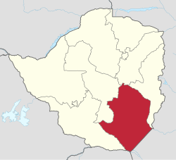
马斯温戈省
马斯温戈省(英语:Masvingo Province,1980年前称维多利亚省)是津巴布韦的一个省,位于该国东南部,东邻莫桑比克,南隅林波波河与南非共和国相望。面积约56,566平方公里,2012年人口1,485,090人[1]。首府马斯温戈。
| 马斯温戈省 Masvingo Province | |
|---|---|
| 辛巴威省份 | |
 马斯温戈省在辛巴威的位置 | |
| 坐标:21°S 31°E / 21°S 31°E | |
| 国家 | 辛巴威 |
| 成立 | 19世纪末 |
| 首府 | 马斯温戈 |
| 面积 | |
| • 总计 | 56,566 平方公里(21,840 平方英里) |
| 人口(2012)[1] | |
| • 总计 | 1,485,090人 |
| • 密度 | 26.3人/平方公里(68人/平方英里) |
| 时区 | CAT(UTC+2) |
| HDI(2017) | 0.532[2] 低 · 第4名 |
区份
编辑马斯温戈省下分9个区份,其中有7个郊区(Rural District)、2个城区(Urban District)。
| 地图 | 编号 | 区名 | 原文 | 下辖行政区数 (Ward) |
面积[注 1] (km2) |
人口 (2012) |
|---|---|---|---|---|---|---|
| 郊区 | ||||||
| 1 | 比基塔区 | Bikita District | 32 | 5,177.00 | 162,356 | |
| 2 | 奇雷济区 | Chiredzi District | 32 | 17,394.57 | 275,759 | |
| 3 | 奇维区 | Chivi District | 32 | 3,545.63 | 166,049 | |
| 4 | 古图区 | Gutu District | 41 | 7,053.58 | 203,083 | |
| 5 | 马斯温戈区 | Masvingo District | 35 | 6,851.64 | 211,215 | |
| 6 | 姆韦内济区 | Mwenezi District | 18 | 13,217.85 | 166,993 | |
| 7 | 扎卡区 | Zaka District | 34 | 3,125.39 | 181,301 | |
| 城区 | ||||||
| 8 | 奇雷济 | Chiredzi | 8 | 22.18 | 30,448 | |
| 9 | 马斯温戈 | Masvingo | 11 | 71.91 | 87,886 | |
| 马斯温戈省 | 243 | 56,459.75 | 1,485,090 | |||
参考资料
编辑- 注释
- ^ 此面积系以联合国人道事务协调厅(OCHA)所发布之图资“辛巴威行政区边界[3]”,透过GIS软体运算获得(采用座标系统:Arc 1950 / UTM Zone 36S),可能与官方数据有所出入。
- 来源
- ^ 1.0 1.1 1.2 1.3 Zimbabwe Population Census 2012: Masvingo Province Report (PDF). Zimbabwe National Statistics Agency. [2019-08-09]. (原始内容存档 (PDF)于2018-10-24). (页面存档备份,存于互联网档案馆)
- ^ 2.0 2.1 Sub-national HDI - Area Database - Global Data Lab. hdi.globaldatalab.org. [2018-09-13]. (原始内容存档于2018-09-23) (英语). (页面存档备份,存于互联网档案馆)
- ^ 3.0 3.1 Zimbabwe administrative levels 0-3 boundaries. The Humanitarian Data Exchange. United Nations Office for the Coordination of Humanitarian Affairs. [2019-08-09]. (原始内容存档于2020-10-30). (页面存档备份,存于互联网档案馆)