哈貝什省
哈貝什省(阿拉伯語:إيالة الحبشة;鄂圖曼土耳其語:ایالت حبش,羅馬化:Eyālet-i Ḥabeş[3]),奧斯曼帝國的一個省份(埃亞萊特)。
| 哈貝什省 إيالة الحبشة ایالت حبش Eyālet-i Ḥabeş | |||||||||||||||||
|---|---|---|---|---|---|---|---|---|---|---|---|---|---|---|---|---|---|
| 奧斯曼帝國的省 | |||||||||||||||||
| |||||||||||||||||
.svg) 旗幟 | |||||||||||||||||
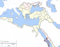
.png) 1795年的吉達哈貝什省 | |||||||||||||||||
| 坐標:21°32′36″N 39°10′22″E / 21.5433°N 39.1728°E | |||||||||||||||||
| 國家 | 奧斯曼帝國 | ||||||||||||||||
| 首府 | 薩瓦金[1]、吉達[1] | ||||||||||||||||
| 面積 | |||||||||||||||||
• 1856年[2] | 503,000平方公里(194,000平方英里) | ||||||||||||||||
| 歷史 | |||||||||||||||||
• 成立 | 1557年 | ||||||||||||||||
• 廢除 | 1872年 | ||||||||||||||||
| |||||||||||||||||
| 今屬於 | |||||||||||||||||
地名語源
編輯該省的名稱「哈貝什」(Ḥabeş)源自阿拉伯語對埃塞俄比亞的稱謂「Ḥabašah」,而這個阿拉伯語地名源自當地人的自稱「Ḥbštm」和「Ḥbśt」(Ḥabashat)[4][5]。
因其地跨紅海兩岸,一些資料中也將其稱為「吉達和哈貝什省」[6]或「哈貝什和漢志」[7]。
歷史
編輯1517年,統治着埃及、巴勒斯坦和敘利亞地區的馬穆魯克蘇丹國被奧斯曼帝國占領[8]。原屬馬穆魯克蘇丹國的吉達被奧斯曼帝國擴建以抵禦葡萄牙人的入侵。隨着奧斯曼帝國將邊界擴展到紅海沿岸的其他地區,16世紀抵達的奧斯曼土耳其人取代蘇丹和阿拉伯半島的穆斯林統治者成為非洲紅海沿岸的主導者[9]。1557年,奧茲迪米爾帕夏占領薩瓦金和馬薩瓦港口,建立哈貝什省。通過不斷征服厄立特里亞內陸[10],1560年代設立伊布林桑賈克[11]。1571年,哈貝什總督擊破了豐吉蘇丹國軍隊對薩瓦金的包圍[11]。哈貝什總督駐馬薩瓦島,控制着馬薩瓦的貿易和稅收,薩瓦金則有海關官員管理。1578年,該省停止擴張,奧斯曼人撤離了大部分的高地。哈貝什總督移駐駐薩瓦金,將馬薩瓦及其腹地交給由貝盧人貴族擔任的「馬薩瓦奈布」管理[12]。在隨後的幾個世紀,奧斯曼政府基本沒有進一步干預當地,維持着間接統治的體系。儘管如此,奧斯曼人還是將馬薩瓦島上的馬薩瓦老城修建為紅海的一個重要港口[13]。
16世紀末,哈貝什總督駐地到經濟上更重要的吉達,吉達位於紅海對岸的阿拉伯半島,儘管18世紀時曾短暫遷至麥地那,但直到19世紀初的絕大多數時間都設在吉達[14]。1517年,占據漢志的奧斯曼帝國在吉達建立了屬於埃及貝勒貝伊利克的吉達桑賈克[15]。隨着吉達發展為紅海沿岸的重要港口,其與對面非洲海岸的哈貝什合併,且哈貝什總督的駐地遷至吉達[16],但仍在薩瓦金和馬薩瓦設有海關官員[17]。最晚至1701年,薩瓦金和馬薩瓦已經被置於吉達的統治之下[18]。
由於距首都較遠,奧斯曼帝國對吉達的控制能力極弱,僅擁名義上的權利[19],總督的任命並不受奧斯曼帝國重視,出任哈貝什總督被認為無異於流放[17]。1803年,瓦哈比叛軍接管漢志的大部分地區,哈貝什總督與麥加謝里夫相比變得無足輕重,甚至被授予從未試圖獲得該總督職位的個人[17]。
1813年,埃及總督穆罕默德·阿里帕夏打響奧斯曼-沙特戰爭,並接手了對哈貝什的管理,其子艾哈邁德·圖順帕夏被任命為哈貝什總督,從而獲得了對薩瓦金和馬薩瓦港口的控制權。1827年,哈貝什重歸奧斯曼帝國的統治。但在1846年,馬薩瓦和薩瓦金再次被授予埃及赫迪夫穆罕默德·阿里,直到他於1849年去世[14]。
1866年,吉達作為一個獨立實體被併入麥加謝里夫領,非洲部分則在1869年後的一系列改制後併入埃及[14]。1871年,哈貝什帕夏被正式撤銷,吉達的長官被降格為穆塔薩勒夫。吉達穆塔薩勒夫領僅存在了一年後重新升級[20],成為行政中心設在麥加的漢志州[20]。
行政區劃
編輯哈貝什省曾下轄伊布林、薩瓦金、哈吉戈、馬薩瓦、塞拉、吉達等桑賈克[14]。1831年時,下轄麥加、麥地那、吉達、延布(Yenbuğ)、塔伊夫、尼羅等里瓦[21]。1849年前還曾設有也門桑賈克,後析置也門省。1860年代,下轄內志、麥加、吉達、麥地那等桑賈克[22]。
地圖
編輯-
 僅控制非洲部分的哈貝什省地圖
 -
 1609年時哈貝什省在奧斯曼帝國的位置
 -
 1795年時哈貝什省在奧斯曼帝國的位置

.png)
參考
編輯- ^ 1.0 1.1 David Lea; Annamarie Rowe. A political chronology of Africa.. Taylor & Francis. 2001: 403 [2013-06-01]. ISBN 978-1-85743-116-2. (原始內容存檔於2022-05-05).
- ^ Thomas Baldwin. Lippincott's Pronouncing Gazetteer: A Complete Pronouncing Gazetteer Or Geographical Dictionary of the World .... J.B. Lippincott. 1856: 1968 [2013-06-01]. (原始內容存檔於2022-05-05).
- ^ Some Provinces of the Ottoman Empire. Geonames.de. [25 February 2013]. (原始內容存檔於27 August 2013).
- ^ Schoff, Wilfred Harvey. The Periplus of the Erythraean Sea: travel and trade in the Indian Ocean. Longmans, Green, and Co. 1912: 62 [28 September 2016].
- ^ Hatke, George. Aksum and Nubia: Warfare, Commerce, and Political Fictions in Ancient Northeast Africa. NYU Press. 2013: 52–53. ISBN 978-0-8147-6066-6.
- ^ National Archives (Great Britain). Islam: 1916-1917. Archive Editions. 2004: 328 [2013-06-01]. ISBN 978-1-84097-070-8. (原始內容存檔於2022-05-05).
Immediately, therefore, after the complete conquest of the Red Sea basin had been accomplished, a new province was formed —the Eyalet of Jeddah and Habecb (Abyssinia), with Jeddah for its chief town. It included the coast of Hejaz and, on the other side, that of Africa; the latter comprising the ports of Suakin, Massowah, Zeila, Berbera, Obok, Tadjuru, Ac, with the territory behind them.
- ^ Almanach de Gotha: annuaire généalogique, diplomatique et statistique. J. Perthes. 1867: 827–829 [2013-06-01]. (原始內容存檔於2014-07-05).
- ^ "History of Arabia." (頁面存檔備份,存於網際網路檔案館) Britannica.com.
- ^ Fred M. Shelley. Nation Shapes: The Story Behind the World's Borders. ABC-CLIO. 2013: 295 [2013-06-10]. ISBN 978-1-61069-106-2. (原始內容存檔於2022-05-05).
- ^ Okbazghi Yohannes. A Pawn in World Politics: Eritrea. University of Florida Press. 1991: 31 [2013-07-23]. ISBN 0-8130-1044-6. (原始內容存檔於2022-05-05).
- ^ 11.0 11.1 Charles le Qusene. Quseir: An Ottoman And Napoleonic Fortress On The Red Sea Coast Of Egypt. American Univ in Cairo Press. 2007: 35 [2013-06-10]. ISBN 978-977-416-009-7. (原始內容存檔於2022-05-05).
- ^ Richard Pankhurst, The Ethiopian borderlands (Lawrenceville: Red Sea Press, 1997), p. 270.
- ^ Massawa | Eritrea. [2022-05-05]. (原始內容存檔於2020-10-18).
- ^ 14.0 14.1 14.2 14.3 Siegbert Uhlig. Encyclopaedia Aethiopica: D-Ha. Otto Harrassowitz Verlag. 2005: 951 [2013-06-01]. ISBN 978-3-447-05238-2. (原始內容存檔於2016-08-09).
- ^ Numan 2005,第60頁.
- ^ Numan 2005,第61頁.
- ^ 17.0 17.1 17.2 John Lewis Burckhardt. Sir W. Ouseley , 編. Travels in Arabia. H. Colburn. 1829: 87–88 [2013-06-02].
- ^ Kenneth R Hall. Secondary Cities and Urban Networking in the Indian Ocean Realm: C. 1400 - 1800. Lexington Books. 2008: 51 [2013-06-01]. ISBN 978-0-7391-2835-0. (原始內容存檔於2022-05-05).
- ^ Sir James Porter. Turkey: its history and progress. Hurst & Blackett. 1854: 104 [2013-06-01].
- ^ 20.0 20.1 Numan 2005,第61-62頁.
- ^ 1831 TARIHINDE OSMANLI IMPARATORLU~UNDA IDARI TAKSIMAT VE NÜFUS. [2022-05-05]. (原始內容存檔於2023-07-07).
- ^ A. Viquesnel. Voyage dans la Turquie d'Europe: description physique et géologique de la Thrace. Bertrand. 1868: 148 [2013-06-01]. (原始內容存檔於2022-05-05).
文獻
編輯- Özbaran, Salih, The Ottoman Response to European Expansion: Studies on Ottoman-Portuguese Relations in the Indian Ocean and Ottoman Administration in the Arab Lands During the Sixteenth Century, Isis Press, 1994
- Numan, Nurtaç, The Emirs of Mecca and the Ottoman Government of Hijaz, 1840-1908, The Institute for Graduate Studies in Social Sciences, November 2005 [2022-05-05], (原始內容存檔於2019-12-14)