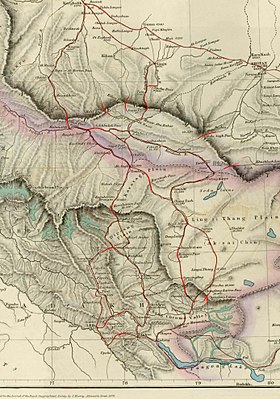
桑株達坂
桑株達坂,海拔5,364公尺(17,598英尺) ,是中國新疆和田地區皮山縣崑崙山脈的一座歷史山口。在以前,這是拉達克和塔里木盆地之間最常見的夏季商隊路線。近年來,除了被當地人使用外,它也成為了中國徒步旅行者的徒步路線。[1]
| 桑株達坂 | |
|---|---|
 桑株達坂(Sanju Pass),位於地圖中間上半部 。 | |
| 海拔 | 5,364公尺(17,598英尺) |
| 穿過 | 桑株古道 |
| 位置 | 中國新疆皮山縣 |
| 山脈 | 崑崙山脈 |
| 坐標 | 36°40′13″N 77°38′45″E / 36.67028°N 77.64583°E |
馱馬古道
編輯從歷史上看,從印度北部到塔里木盆地的主要路線穿過拉達克的Nubra河谷,穿過冰雪覆蓋的Sasser Pass (5,411公尺或17,753英尺) 和更高的喀喇崑崙山口 (5,540公尺或18,180英尺),經過相對容易Suget Pass (36°09′33″N 78°00′32″E / 36.15917°N 78.00889°E) 到賽圖拉鎮的中轉站。夏季時,商隊通常從那裡向北穿過桑株達坂,到達桑株鎮。
桑株鎮往北到達塔里木盆地的皮山縣固瑪鎮 (Guma),往西北可到達葉城縣喀格勒克鎮 (Karghalik) 和莎車縣,往東北到達和田市 (古于闐國)。[2] 桑株鎮往西北經葉城縣洛克鄉博熱村(Bora) ,在博熱村可與穿過巴薩勒格達坂 (Kilian Pass) 的克里陽 (Kilian) 古道路線會合。往西北到葉城縣喀格勒克鎮 ,在喀格勒克鎮可與經柯克亞鄉 (Kugiar) 的庫地古道(葉爾羌古道)和經Kilik Pass (36°40′13″N 77°38′45″E / 36.67028°N 77.64583°E) (不要與從罕薩河谷往北的基里克達坂混淆)[3]路線會合。[4]
從賽圖拉鎮到塔里木盆地,旅行者可以選擇三個達坂,由西而東分別是Kilik Pass (36°40′13″N 77°38′45″E / 36.67028°N 77.64583°E)、 巴薩勒格達坂 (Kilian Pass) 和桑株達坂。但在 19 世紀,商隊通常的路線是穿過桑株達坂。
Kilik Pass 以前經常被在莎車縣的巴爾蒂人使用,並且在每次中轉階段都可提供大量的飼料和燃料。據說這是最簡單、最短的路線。由於在賽圖拉鎮下游約 14公里(8.7英里)處的吐日蘇河(Toghra Su)洪水泛濫,商隊也經常在炎熱的天氣中長時間無法進入。 巴薩勒格達坂(Kilian Pass)比桑株達坂要高,對於滿載馬匹的馬來說也不切實際,但並沒有那麼難穿過。但是達坂的山頂總是被冰雪覆蓋,對於滿載的小馬來說是不可行的——必須使用氂牛。商隊走這條路到克里陽鄉的時候,和商隊走桑株達坂往葉城縣喀格勒克鎮(Karghalik) ,已經到達了葉城縣洛克鄉博熱村(Bora)了。[5]
1878年清朝平息了同治陝甘回亂後,[6]重新控制崑崙山脈下的喀拉喀什河河谷,至此一直被認為是新疆的一部。[7] 中國新藏公路,從塔里木盆地的葉城縣向南穿過賽圖拉鎮,穿過阿克賽欽地區,進入西藏自治區西北部。[8]
參見
編輯腳註
編輯- ^ 王鐵男. 穿越桑株古道-翻越桑株达坂 [Through the Sanju Trail — Over the Sanju Pass]. Sohu Blog. 2010-03-15 [2017-02-01] (中文).
- ^ Hill (2009), pp. 200-203, 208.
- ^ Hill (2009), p. 200.
- ^ Forsyth (1875), p. 245.
- ^ Forsyth (1875), pp. 244-245.
- ^ Millward (2007), p. 130.
- ^ Stanton, Edward. (1908) Atlas of the Chinese Empire. Prepared for the China Inland Mission. Morgan & Scott, Ltd. London. Map. No. 19 Sinkiang.
- ^ National Geographic Atlas of China, p. 28. (2008). National Geographic Society, Washington, D.C.
參考
編輯- Forsyth, T. D. (1875). Report of a Mission to Yarkund in 1873 : vol.1. Calcutta. [1] (頁面存檔備份,存於網際網路檔案館)
- Grenard, Fernand (1904). Tibet: The Country and its Inhabitants. Fernand Grenard. Translated by A. Teixeira de Mattos. Originally published by Hutchison and Co., London. 1904. Reprint: Cosmo Publications. Delhi. 1974.
- Hill, John E. (2009) Through the Jade Gate to Rome: A Study of the Silk Routes during the Later Han Dynasty, 1st to 2nd Centuries CE. John E. Hill. BookSurge, Charleston, South Carolina. ISBN 978-1-4392-2134-1.
- Millward, James A. (2007). Eurasian Crossroads: A History of Xinjiang. Columbia University Press, New York. ISBN 978-0-231-13924-3.
- Roerich, George N. (1931). Trails to Inmost Asia: Five Years of Exploration with the Roerich Central Asian Expedition, pp. 49–51. First reprint in India. Book Faith India, Delhi. (1996). ISBN 81-7303-032-4.
- Shaw, Robert. (1871). Visits to High Tartary, Yarkand and Kashgar. Reprint by Oxford University Press (1984). ISBN 0-19-583830-0.
- Younghusband, Francis E. (1896). The Heart of a Continent. John Murray, London. Facsimile reprint: (2005) Elbiron Classics.
| 喀喇崑崙走廊和阿克賽欽的相關位置圖 |
|---|
|
喀喇崑崙走廊和阿克賽欽的相關位置圖 圖例: 6:布洛阿特峰 7:加舒爾布魯木IV峰 K3 8:加舒爾布魯木II峰 K4 9:加舒爾布魯木I峰 K5 10:錫亞康戈里峰 11:特拉木坎力I峰 12:Apsarasas Kangri I 13:皇冠山 14:克勒青河 15:喀喇崑崙山口 16:斗拉特別奧里地 - 天文點 LAC 17:加勒萬河 18:空喀山口 19:神仙灣 20:天文點 21:河尾灘 22:加勒萬前進基地 23:溫泉 24:空喀山口邊防連 25:空喀山口事件 (勝利山) 26:拉那克山口 27:阿克賽欽湖 28:甜水海 29:喀拉喀什河 30:葉爾羌河 31:熱斯喀木村(Raskam) 32:麻扎(Mazar) 33:柯克阿特達坂 34:賽圖拉哨卡(Xaidulla) 35:賽圖拉鎮 36:康西瓦(Kangxiwar) 37:大紅柳灘(Dahongliutan) 38:Suget Pass 39:桑株達坂 40:印地他什達坂 41:莎車縣莎車鎮 42:喀格勒克鎮 43:博熱(Bora) 44:柯克亞鄉 45:固瑪鎮 46:桑株鎮 47:和田市 48:于田縣 49:玉龍喀什河 50:克里雅河 51:克里雅山口 52:郭扎錯 53:邦達錯 54:清澈湖 55:美馬錯 56:龍木錯 57:松西村 |
