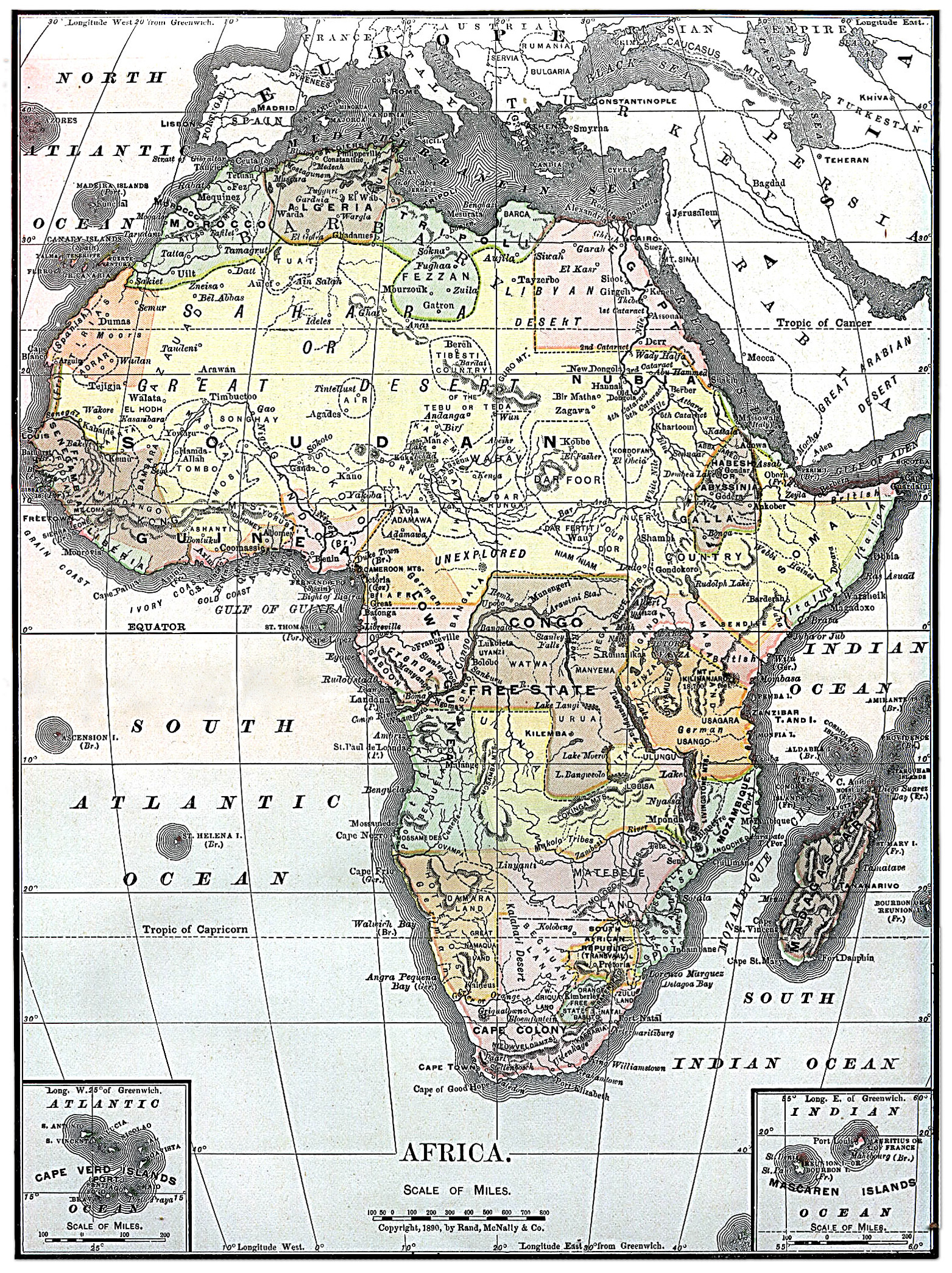
File:Map of Africa from Encyclopaedia Britannica 1890.jpg
預覽大小:448 × 599 像素。 其他解析度:179 × 240 像素 | 359 × 480 像素 | 574 × 768 像素 | 766 × 1,024 像素 | 1,563 × 2,090 像素。
原始檔案 (1,563 × 2,090 像素,檔案大小:2.07 MB,MIME 類型:image/jpeg)
摘要
授權條款
|
本作品在其來源國以及其他著作權期限是作者逝世後70年或以下的國家與地區屬於公有領域。 | |
| 此作品無已知的著作權限制,亦不受所有相關和鄰接的權利限制。 | |
| This image comes from the 13th edition of the Encyclopædia Britannica or earlier. The copyrights for that book have expired in the United States because the book was first published in the US with the publication occurring before January 1, 1929. As such, this image is in the public domain in the United States. |  |
This image was selected as picture of the day on Wikimedia Commons for 24 June 2005. It was captioned as follows: English: Map of Africa 1890 Other languages:
Brezhoneg : Kartenn eus Afrika er bloaz 1890 Čeština: Mapa Afriky z roku 1890 Cymraeg: Map o Affrica yn y flwyddyn 1890 Dansk: Kort over Africa fra 1890 Deutsch: Karte von Afrika aus dem Jahr 1890 English: Map of Africa 1890 Español: Mapa de África del año 1890 Français : Carte du continent africain des années 1890. Galego: Mapa de África do ano 1890 Latina: Tabula geographica Africae, 1890 Nederlands: Kaart van Afrika uit 1890 Norsk nynorsk: Kart over Afrika frå 1890 Português: Mapa de África 1890 Slovenščina: Zemljevid Afrike, 1890. Suomi: Vuoden 1890 Encyclopaedia Britannican Afrikan kartta Svenska: En karta över Afrika från 1890. Русский: Карта Африки 1890-ого года ગુજરાતી : આફ્રિકાનો નક્શો, ૧૮૯૦ ไทย: แผนที่ทวีปแอฟริกา ค.ศ. ๑๘๙๐ 日本語: アフリカの地図 (1890年) 中文: 非洲1890年地图 中文(繁體): 非洲1890年地圖 粵語: 1890 年嘅非洲地圖 閩南語 / Bân-lâm-gú: 1890 nî Hui-chiu ê tē-tô·. עברית : מפה של אפריקה מ1890 |
檔案歷史
點選日期/時間以檢視該時間的檔案版本。
| 日期/時間 | 縮圖 | 尺寸 | 使用者 | 備註 | |
|---|---|---|---|---|---|
| 目前 | 2010年8月4日 (三) 18:30 | | 1,563 × 2,090(2.07 MB) | Orionist | fixed warp on the top and removed the seam in the middle |
| 2010年8月4日 (三) 18:15 |  | 1,563 × 2,090(1.57 MB) | Orionist | higher resolution version | |
| 2010年8月4日 (三) 06:48 |  | 787 × 1,054(425 KB) | PawełMM | warp on top fixed | |
| 2004年12月5日 (日) 12:03 |  | 787 × 1,054(410 KB) | TOR | Map of Africa from Encyclopaedia Britannica, 1890 {{PD}} |
檔案用途
下列頁面有用到此檔案:
全域檔案使用狀況
以下其他 wiki 使用了這個檔案:
- arz.wikipedia.org 的使用狀況
- azb.wikipedia.org 的使用狀況
- bg.wiktionary.org 的使用狀況
- da.wikipedia.org 的使用狀況
- en.wikipedia.org 的使用狀況
- User:Kentfowl
- User:Enlil Ninlil
- User:Hibernian
- User:Pwjb
- User:Cold Water
- User:ForestAngel
- User:Mr A
- User:Orionist
- User:Reno vercetti
- User talk:Gidonb/Archive 2008
- User:PinkPanthress
- User:El monty
- Wikipedia talk:WikiProject History/Task force images
- User:Patricius Augustus
- User:1c33y37
- User:Bubbles02
- User:HalleluYHWH
- User:HalleluYHWH/Userboxes/Africa
- User:Secret Saturdays
- User:Alumnum
- User:Yertul
- User:Sparrowhawk64
- User:Saukkomies/My userboxes
- User:Sewati
- User:HypertimeTraveller
- User:SocialPhysics
- Wikipedia:Graphics Lab/Photography workshop/Archive/Aug 2010
- User:Orionist/Gallery
- User:Metallurgist/userboxes
- User:Pacificus Viridis
- User:Mikisrb
- User:BrunGunth
- User:FeleciaQ
- User:Smart30
- User:Lyaika
- User:Flinders Petrie
- User:Bouncingnewsgreen
- User:Polskivinnik
- User:Ilmurov
- User:Autioitua
- User:IjonTichyIjonTichy
- User:Yo222
- User:Terminator484/sandbox
- User:Oxyaena
- User:Bodney/sandbox
- User:GangGangQuokka2
檢視此檔案的更多全域使用狀況。