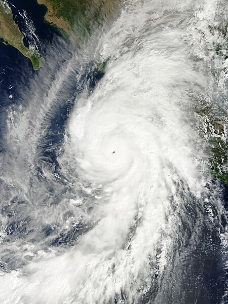
File:Patricia 2015-10-23 1730Z.jpg

預覽大小:450 × 600 像素。 其他解析度:180 × 240 像素 | 360 × 480 像素 | 576 × 768 像素 | 768 × 1,024 像素 | 1,536 × 2,048 像素 | 6,000 × 8,000 像素。
原始檔案 (6,000 × 8,000 像素,檔案大小:9.33 MB,MIME 類型:image/jpeg)
檔案歷史
點選日期/時間以檢視該時間的檔案版本。
| 日期/時間 | 縮圖 | 尺寸 | 使用者 | 備註 | |
|---|---|---|---|---|---|
| 目前 | 2016年11月12日 (六) 16:24 |  | 6,000 × 8,000(9.33 MB) | Meow | Corrected the ratio. |
| 2015年10月23日 (五) 20:20 |  | 6,210 × 8,280(9.44 MB) | Meow | User created page with UploadWizard |
檔案用途
下列15個頁面有用到此檔案:
- 2015年太平洋颶風季
- 2015年太平洋飓风季时间轴
- 五级太平洋飓风列表
- 颶風派翠莎
- 飓风帕特里夏的气象历史
- Wikipedia:典范条目/2016年8月
- Wikipedia:典范条目/2016年8月13日
- Wikipedia:典范条目/2018年11月
- Wikipedia:典范条目/2018年11月24日
- Wikipedia:典范条目/2022年8月
- Wikipedia:典范条目/2022年8月29日
- Wikipedia:典范条目/飓风帕特里夏的气象历史
- Wikipedia:潜在优良和典范话题
- Wikipedia:特色圖片評選/存檔/2017年6月
- Wikipedia:特色圖片評選/颶風帕特里夏
全域檔案使用狀況
以下其他 wiki 使用了這個檔案:
- ar.wikipedia.org 的使用狀況
- azb.wikipedia.org 的使用狀況
- bn.wikipedia.org 的使用狀況
- ca.wikipedia.org 的使用狀況
- cs.wikipedia.org 的使用狀況
- de.wikipedia.org 的使用狀況
- en.wikipedia.org 的使用狀況
- Cyclone
- Talk:Tropical cyclone
- Talk:Saffir–Simpson scale
- Talk:Hurricane Iniki
- Talk:2004 Pacific hurricane season
- Talk:Hurricane Linda (1997)
- Talk:2005 Pacific hurricane season
- Talk:1977 Pacific hurricane season
- Talk:List of California hurricanes
- Wikipedia:WikiProject Tropical cyclones
- Talk:Hurricane Diana
- Talk:Hurricane Cesar–Douglas
- Wikipedia talk:WikiProject Tropical cyclones
- Talk:Hurricane Fifi–Orlene
- Talk:Hurricane Anita
- Talk:Hurricane Joan–Miriam
- Talk:2002 Pacific hurricane season
- Talk:2003 Pacific hurricane season
- Talk:2000 Pacific hurricane season
- Talk:2001 Pacific hurricane season
- Talk:1999 Pacific hurricane season
- Talk:1998 Pacific hurricane season
- Talk:1997 Pacific hurricane season
- Talk:1996 Pacific hurricane season
- Talk:1995 Pacific hurricane season
- Talk:1994 Pacific hurricane season
- Talk:1993 Pacific hurricane season
- Talk:1992 Pacific hurricane season
- Talk:1991 Pacific hurricane season
- Talk:1990 Pacific hurricane season
- Talk:1989 Pacific hurricane season
- Talk:1988 Pacific hurricane season
- Talk:1987 Pacific hurricane season
- Talk:1986 Pacific hurricane season
- Talk:1985 Pacific hurricane season
- Talk:1984 Pacific hurricane season
- Talk:1983 Pacific hurricane season
- Talk:1982 Pacific hurricane season
- Talk:1981 Pacific hurricane season
- Talk:1980 Pacific hurricane season
檢視此檔案的更多全域使用狀況。


