菲臘港市
菲臘港市(英語:City of Port Phillip)是澳洲維多利亞州的一個地方政府區域,位於菲臘港灣北岸,墨爾本市(市中心)以南,面積 20.7 km²,2018年人口 113,200人。[1]
| 菲臘港市 | |
|---|---|
 | |
 菲臘港市 | |
| 坐標:37°51′00″S 144°58′00″E / 37.85°S 144.9667°E | |
| 國家 | |
| 建立 | 1994 |
| 政府所在地 | 聖基爾達 |
| 政府 | |
| • 市長 | Cr. Marcus Pearl |
| 面積[1] | |
| • 總計 | 20.7 平方公里(8.0 平方哩) |
| 人口(2018)[1] | |
| • 總計 | 113,200人 |
| • 密度 | 4,871.1人/平方公里(12,616人/平方哩) |
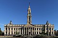
菲臘港市於1994年合併成立,由三個區組成,大致相當於原先的三個市:聖基爾達(St Kilda)、南墨爾本(South Melbourne)和墨爾本港(Port Melbourne)[2]。議會辦公室目前位於聖基爾達市政廳、墨爾本港市政廳和南墨爾本市政廳。
-
 聖基爾達市政廳
 -
 南墨爾本市政廳


參考 編輯
- ^ 1.0 1.1 1.2 3218.0 – Regional Population Growth, Australia, 2017-18: Population Estimates by Local Government Area (ASGS 2018), 2017 to 2018. Australian Bureau of Statistics. Australian Bureau of Statistics. 27 March 2019 [25 October 2019]. (原始內容存檔於2019-03-27). Estimated resident population, 30 June 2018.
- ^ Port Phillip. [9 September 2006]. (原始內容存檔於3 March 2016).