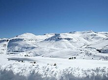
馬洛蒂山
29°0′0″S 28°25′0″E / 29.00000°S 28.41667°E

馬洛蒂山(英語:Maloti Mountains)是萊索托的山脈,處於首都馬塞盧以東90公里,屬於德拉肯斯山脈的一部分,長150公里、寬90公里,最高點塔巴納恩特萊尼亞納山海拔高度3,482米。
參考資料
編輯- Thabana Ntlenyana (mountain, Lesotho) - Britannica Online (頁面存檔備份,存於互聯網檔案館)
- Maloti Mountains - Britannica Online (頁面存檔備份,存於互聯網檔案館)
- https://archive.org/details/bub_gb_WLZRxM9vfXoC
- https://www.theatlantic.com/photo/2018/07/afriski-lesothos-only-ski-resort/565361/ (頁面存檔備份,存於互聯網檔案館)
- Maloti-Drakensberg Transfrontier Conservation Area (頁面存檔備份,存於互聯網檔案館)
- https://web.archive.org/web/20120130182044/
- http://www.maloti.org.ls/home/ (頁面存檔備份,存於互聯網檔案館)
- https://web.archive.org/web/20180426150250/
- http://www.peaceparks.org/tfca.php?pid=27&mid=1004 (頁面存檔備份,存於互聯網檔案館) Maloti-Drakensberg
- http://funkymunky.co.za/goldengate.html (頁面存檔備份,存於互聯網檔案館) Photographs of Golden Gate Highlands National Park
| 這是一篇與萊索托地理相關的小作品。您可以透過編輯或修訂擴充其內容。 |