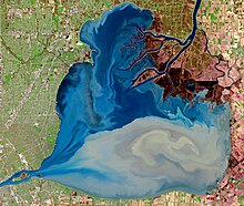
聖克萊爾湖 (北美洲)
加拿大湖泊
42°28′N 82°40′W / 42.467°N 82.667°W

聖克萊爾湖(英語:Lake St. Clair ,法語:Lac Sainte-Claire)是北美洲的淡水湖,位於加拿大安大略省和美國密芝根州之間接壤的邊境,長42公里,寬39公里,面積1,114平方公里,海拔高度175米,平均水深3.4米,最大水深8.2米,蓄水量3.4立方公里,湖岸線長度272公里。
外部連結
編輯- The Lake St.Clair Network (頁面存檔備份,存於互聯網檔案館) Networking boaters, anglers, and water sport enthusiasts
- Fishing Reports for the Area (頁面存檔備份,存於互聯網檔案館) Fishing Reports for the Area.
- Terry Pepper on lighthouses of the Western Great Lakes. (頁面存檔備份,存於互聯網檔案館)
- Bathymetry of Lake Erie & Lake St. Clair (頁面存檔備份,存於互聯網檔案館) - NGDC
- National Data Buoy Center page for Lake St. Clair station LSCM4 (頁面存檔備份,存於互聯網檔案館) Current weather conditions from NOAA
| 這是一篇與加拿大相關的地理小作品。您可以透過編輯或修訂擴充其內容。 |
| 這是一篇與密芝根州相關的小作品。您可以透過編輯或修訂擴充其內容。 |