厄加勒斯國家公園
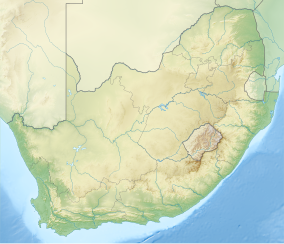
厄加勒斯國家公園是南非國家公園之一,位於西開普南奧弗貝格地區的厄加勒斯角平原上,距開普敦東南部約200千米。公園沿著甘斯拜和斯特瑞斯拜之間的海岸平原延伸,包含南非南端的厄加勒斯角。至2009年1月占地面積為20,959km²(51,790英畝)。[1]
| 厄加勒斯國家公園 | |
|---|---|
 厄加勒斯角的燈塔 | |
| 位置 | 南非西開普 |
| 最近城市 | 斯特瑞斯拜 |
| 座標 | 34°50′S 20°00′E / 34.833°S 20.000°E |
| 面積 | 20,959公頃(51,790英畝) |
| 建立 | 1998年9月14日 |
| 管理機構 | 南非國家公園 |
| www | |
旅遊景點
編輯公園主要的旅遊景點為厄加勒斯角,南非的最南端,也是大西洋和印度洋正式交匯點。附近時厄加勒斯燈塔,是南非第二古老的燈塔,在那還有一座小博物館和茶室。
參考資料
編輯- ^ Agulhas National Park: Park Management Plan 2009 – 2013 (PDF). South African National Parks: 9. 24 February 2009 [13 February 2010]. (原始內容存檔 (PDF)於2019-12-21).
延伸連結
編輯- Agulhas National Park (頁面存檔備份,存於網際網路檔案館) at South African National Parks
