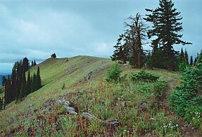
尤馬蒂拉國家森林
尤馬蒂拉國家森林(英語:Umatilla National Forest)位於俄勒岡州東北部、華盛頓州東南部的藍山山脈間,面積1.4 × 10⁶英畝(5,700平方公里)。依照林地面積降序排列,森林分布於尤馬蒂拉縣、格蘭特縣、哥倫比亞縣、莫羅縣、瓦洛瓦縣、猶尼昂縣、加菲爾德縣、阿索廷縣、惠勒縣、瓦拉瓦拉縣,其中超過四分之三的面積處於俄勒岡州境內。[4]
| 尤馬蒂拉國家森林 | |
|---|---|
IUCN分類VI(資源管理保護區) | |
 尤馬蒂拉國家森林內的 Wenaha–Tucannon 原野 | |
| 位置 | 美國俄勒岡州、華盛頓州 |
| 最近城市 | 埃爾金 |
| 座標 | 45°38′00″N 118°11′00″W / 45.63333°N 118.18333°W |
| 面積 | 1,407,087英畝(5,694平方公里)[1] |
| 建立 | 1908年7月1日[2] |
| 訪客量 | 703,000[3] (2006年) |
| 管理機構 | 美國國家森林局 |
| 網站 | Umatilla National Forest |
參考資料
編輯- ^ Land Areas of the National Forest System (PDF). U.S. Forest Service. January 2012 [2012-06-30]. (原始內容存檔 (PDF)於2013-01-16).
- ^ The National Forests of the United States (PDF). ForestHistory.org. [2012-07-30]. (原始內容存檔 (PDF)於2013-02-12).
- ^ Revised Visitation Estimates (頁面存檔備份,存於網際網路檔案館) - National Forest Service
- ^ Table 6 - NFS Acreage by State, Congressional District and County (頁面存檔備份,存於網際網路檔案館) - United States Forest Service - September 30, 2007
外部連結
編輯- Umatilla National Forest (頁面存檔備份,存於網際網路檔案館), USDA Forest Service
| 這是一篇與美國地理相關的小作品。您可以透過編輯或修訂擴充其內容。 |
