沙加緬度河
沙加緬度河(英語:Sacramento River)是美國加利福尼亞州最長的河流。
| 沙加緬度河 Río Sacramento | |
|---|---|
 自沙加緬度的泵站眺望沙加緬度河 | |
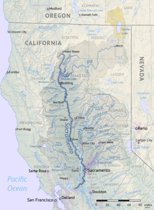
 沙加緬度河流域地圖 | |
| 別名 | Rio del Santísimo Sacramento |
| 國家 | |
| 州/省 | |
| 城市 | 芒特沙斯塔 · 鄧斯繆爾 · 雷丁 · 安德森 · 雷德布拉夫 · 普林斯頓 · 科盧薩 · 戴維斯 · 沙加緬度 · 西沙加緬度 · 艾列頓 · 里奧維斯塔 · 安提阿克 |
| 流域 | |
| 源頭 | Confluence of Middle and South Forks |
| • 位置 | 近沙斯塔山 |
| • 座標 | 41°16′24″N 122°24′05″W / 41.27333°N 122.40139°W[2] |
| • 海拔 | 3,674英尺(1,120米)[1] |
| 河口 | 休森灣 |
| • 位置 | 康特拉科斯塔縣-索拉諾縣邊界 |
| • 座標 | 38°03′48″N 121°51′10″W / 38.06333°N 121.85278°W[2] |
| • 海拔 | 0英尺(0米) |
| 流域面積 | 26,500 sq mi(69,000 km2)[3] |
| 本貌 | |
| 長度 | 400 mi(640 km), 北-南[4] |
| 流量 | |
| • 地點 | 近沙加緬度[5] |
| • 平均流量 | 28,139 cu ft/s(796.8 m3/s) |
| • 最小流量 | 3,970 cu ft/s(112 m3/s) |
| • 最大流量 | 489,000 cu ft/s(13,800 m3/s) |
| 特徵 | |
| 左岸支流 | 皮特河、鹿溪、峰溪、羽毛河、亞美利加河 |
| 右岸支流 | 克萊爾溪、棉木溪、石溪、卡什溪、普塔溪 |
| 別稱 | 沙加河、西方尼羅河[6] |
該河發源於喀斯喀特山脈的沙斯塔山附近,全長382英里。該河由發源地開始流向西南,穿過位於太平洋海岸山脈和內華達山脈之間的中央谷地北部,然後在與亞美利加河匯合的地方不遠,它就連同聖華金河形成沙加緬度河三角洲,然後注入舊金山灣北部。其主要支流為皮特河、番澤河、梅克勞德河以及亞美利加河。其中皮特河最長,但番澤河與美國河的流量更大。
人工運河使該河自舊金山灣入海口以上180英里都可以航行,遠洋輪可一直上溯至沙加緬度。開闢航道後,有時會發現一些海洋生物如灰鯨和海獅等誤入河中覓食或尋求庇護,無法重返太平洋。

參考文獻
編輯- ^ South Fork Sacramento River. Geographic Names Information System. United States Geological Survey. 1981-01-19 [August 27, 2010].
- ^ 2.0 2.1 Sacramento River. Geographic Names Information System. United States Geological Survey. 1981-01-19 [August 27, 2010].
- ^ Boundary Descriptions and Names of Regions, Subregions, Accounting Units and Cataloging Units. U.S. Geological Survey. [August 22, 2010]. (原始內容存檔於April 27, 2012).
- ^ Benke and Cushing, p. 547
- ^ Discharge figure is a combination of USGS gage 11447650 Sacramento River at Freeport and USGS 11453000 Yolo Bypass near Woodland. Flood flows diverted around the Sacramento area via the Sacramento River Flood Control Project are recorded by the Yolo Bypass gage.
- ^ Angel, Devanie. The 'reasonable' environmentalist: When John Merz talks about the Sacramento River, people listen. Chico News & Review. Sacramento River Preservation Trust. December 5, 2002 [September 5, 2010]. (原始內容存檔於September 2, 2004).