1906年舊金山大地震
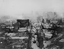
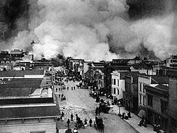
1906年舊金山大地震,發生於1906年4月18日清晨5點13分左右,芮氏規模為7.8,震央位於接近舊金山的聖安地列斯斷層上。[7]自奧勒岡州到加州洛杉磯,甚至是位於內陸的內華達州都能感受到地震的威力。這場地震及隨之而來的大火,對舊金山造成了嚴重的破壞,可以說是美國歷史上主要城市所遭受最嚴重的自然災害之一(參見颶風卡崔娜)。
| UTC時間 | 1906-04-18 13:12:27 |
|---|---|
| ISC事件 | 16957905 |
| USGS-ANSS | 目錄 |
| 當地日期 | 1906年4月18日 |
| 當地時間 | 當地時間05:12 |
| 規模 | 7.9 Mw[1] |
| 震源深度 | 5 mi(8.0 km)[2] |
| 震央 | 37°45′N 122°33′W / 37.75°N 122.55°W[2] |
| 類型 | Strike-slip[3] |
| 影響地區 | 美國北岸 舊金山灣區 中央海岸 |
| 最大震度 | XI (Extreme)[4] |
| 海嘯 | 有[5] |
| 傷亡 | 700–3,000+[6] |


當時,政府官員擔心若公布真正的死亡人數,恐怕會造成地價下跌,並影響到重建這個城市所需的一切,因此捏造數據稱死亡人數只有478人。時至今日,保守估計死亡人數在3,000人以上,甚至可能高達6,000人。傷亡者大部分集中在舊金山,而在其他的舊金山灣區則約有189人死亡。聖塔羅莎、聖荷西以及史丹佛大學也都遭受到嚴重的損害。
40萬人口中,約有22.5至30萬人無家可歸,其中約有一半的難民離開灣區到奧克蘭。報刊消息稱在金門公園、Panhandle 公園,以及從Ingleside到北灘的海灘上,都布滿了臨時搭建的帳棚。
這次等級如此之高的地震,被清楚地以相片記錄下來,也使得後來地震學的科學研究蓬勃發展。總計,當時地震所造成的損失,估計高達4億美金。
隨之而來的大火
編輯和這場大地震以及隨後的餘震相比,隨之而來的火災造成的財產損失甚至更大。城內發生了多處火災,一些火災是由於地震導致的天然氣管道破裂引發的,有一些是人為縱火,或者是臨時帳篷的篝火引發的。因為保險公司只對火災損失而非地震損失進行賠償,有些屋主就放火燒自己的已經被地震破壞的房子以便獲得賠償。美國陸軍信息部萊納德D·韋爾德曼上尉在報告中提到當時一位消防員告訴自己附近的居民在焚燒他們的房子。因為他們被告知被地震損壞的房子不會賠償,除非房子同時也受到火災。
因為供水系統仍舊癱瘓,消防局只能有很有限的資源去利用。在市中心,幾處相近大火混合成了一場更大的火災。當時,有記者報道中提到其他地方的人們應該明白,不是舊金山城內某些地方發生火災,而是整個舊金山城都在大火籠罩之下。這場大火最終摧毀了市中心雲尼斯大道的超過500座樓房。雲尼斯大道是一條將舊金山一分為二並且直通舊金山海岸的大動脈通道。
當時有錯誤的報道說市長Eugene Schmitz和將軍Frederick Funston頒布了戒嚴令。實際上,市長只頒布了一個允許警察和士兵可以當場對趁亂搶劫者開槍的命令。總共有大約500人被槍打傷。政府也盡力控制火勢,他們採用炸毀火災區邊緣的建築物的辦法來製造隔離帶,可是事與願違,火藥把燃燒物炸得更遠引發更大規模火災。
災民安置
編輯- 美國陸軍修建了5,610套紅木和冷杉木的救濟房。這些提供給二萬名無家可歸的人的住房是由John Mclaren 設計。救濟房被分為11個區,並且修建的相近, 然後以2美元的月租出租給人們直到他們的家園重建結束。這些救濟房都是草綠色,一方面為了和周邊環境協調,另一方面也因為軍隊手頭上有大量的草綠色漆。這些救濟房最多時候接納的人數高達16,448。但是到1907年,大多數人都已經搬出了救濟房。之後這些救濟房被重新利用,成為了車庫,倉庫,或者商店。
分析
編輯- 在羅森(1908)的報告中提到了一個關於地震震度的重要特點,地震的震度和地下地質情況有明顯的關聯。沉積物填滿的河谷遭受的地震震度比附近的河床岩石地的要大,並且,最嚴重的地震發生在舊金山海岸的填海造地坍塌的地方。現代地震區劃學說的經驗證明不同的地質結構擁有不同的地震災害效果。
影像
編輯|
|
參考資料
編輯- ^ Where Can I Learn More About the 1906 Earthquake?. Berkeley Seismological Laboratory. 2008-01-28. (原始內容存檔於2008-03-27).
- ^ 2.0 2.1 Location of the Focal Region and Hypocenter of the California Earthquake of April 18, 1906. [2018-06-18]. (原始內容存檔於2011-07-20).
- ^ Segall, P.; Lisowski, M., Surface Displacements in the 1906 San Francisco and 1989 Loma Prieta Earthquakes, Science (American Association for the Advancement of Science), 1990, 250 (4985): 1241–4 [2018-11-15], Bibcode:1990Sci...250.1241S, PMID 17829210, doi:10.1126/science.250.4985.1241, (原始內容存檔於2015-09-24)
- ^ Stover, C.W.; Coffman, J.L., Seismicity of the United States, 1568–1989 (Revised), U.S. Geological Survey professional paper 1527, United States Government Printing Office: 75, 1993 [2018-11-15], (原始內容存檔於2019-04-13)
- ^ Geist, E.L.; Zoback, M.L., Analysis of the tsunami generated by the Mw 7.8 1906 San Francisco earthquake, Geology (Geological Society of America), 1999, 27 (1): 15–18 [2018-11-15], Bibcode:1999Geo....27...15G, doi:10.1130/0091-7613(1999)027<0015:aottgb>2.3.co;2, (原始內容存檔於2017-06-05)
- ^ USGS, Casualties and damage after the 1906 Earthquake, United States Geological Survey, [2018-11-15], (原始內容存檔於2008-06-17)
- ^ 存档副本. [2006-02-07]. (原始內容存檔於2008-12-01).
- ^ 《清實錄‧德宗景實錄》,卷557。
- Lawson, Andrew C., The California Earthquake of April 18, 1906. Report of the State Earthquake Investigation Commission, Carnegie Institution of Washington,1908。
- Reid, H. F., The Mechanics of the Earthquake, Vol. 2 in The California Earthquake of April 18, 1906. Report of the State Investigation Commission, Carnegie Institution of Washington, 1910。
外部連結
編輯- The Great 1906 Earthquake and Fire(頁面存檔備份,存於網際網路檔案館) from the Museum of the City of San Francisco website
- San Francisco-1906(頁面存檔備份,存於網際網路檔案館) Extensive alalysis, description and photos of the earthquake written by Thomas Newport, a UK Student, in 2006. Brief, concise and excellent for quick research.
- The Great 1906 Earthquake and Fire(頁面存檔備份,存於網際網路檔案館) from the Bancroft Library,includes interactive maps and panoramas.
- 1906 San Francisco Quake and Intensity Maps for that earthquake(頁面存檔備份,存於網際網路檔案館),from the U.S. Geological Survey site
- Several videos of the aftermath,from the Internet Archive website
- Interactive Earthquake Panoramas(頁面存檔備份,存於網際網路檔案館),from a website maintained by a Pennsylvanian graphic artist
- San Francisco in Ruins,Aerial Photographs of George R. Lawrence,reprinted from Landscape, Vol. 30, No. 2
- A Personal Account(頁面存檔備份,存於網際網路檔案館)
- 1906 San Francisco Earthquake photos at Western Mining History
- JB Monaco Photography(頁面存檔備份,存於網際網路檔案館),Images of the 1906 SF Earthquake from the well-known North Beach photographer
- Before and After the Great Earthquake and Fire: Early Films of San Francisco, 1897-1916(頁面存檔備份,存於網際網路檔案館) and, in particular, San Francisco earthquake and fire, April 18, 1906(頁面存檔備份,存於網際網路檔案館) from the Library of Congress
- San Francisco-1906(頁面存檔備份,存於網際網路檔案館) Extensive alalysis, description and photos of the earthquake written by Thomas Newport, a UK Student, in 2006.
