File:Nya Sverige.svg

此SVG文件的PNG预览的大小:342 × 599像素。 其他分辨率:137 × 240像素 | 274 × 480像素 | 439 × 768像素 | 585 × 1,024像素 | 1,170 × 2,048像素 | 720 × 1,260像素。
原始文件 (SVG文件,尺寸为720 × 1,260像素,文件大小:461 KB)
摘要
| 描述 |
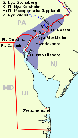
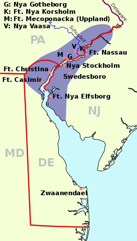
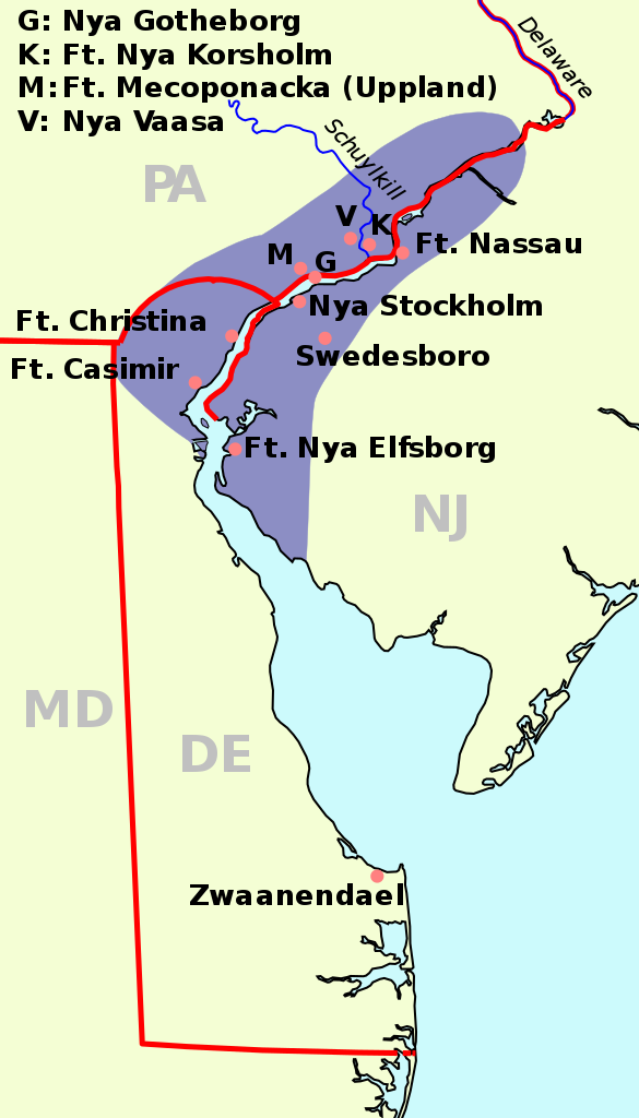
English: The map of New Sweden, 1638 Deutsch: Karte von Neu-Schweden, 1638. Русский: Карта Новой Швеции, 1638 год |
| 日期 | (UTC) |
| 来源 | |
| 作者 |
|
| SVG开发 |
| See also: Nieuw Nederland and Nya Sverige |
本文件采用知识共享署名-相同方式共享 3.0 未本地化版本许可协议授权。
- 您可以自由地:
- 共享 – 复制、发行并传播本作品
- 修改 – 改编作品
- 惟须遵守下列条件:
- 署名 – 您必须对作品进行署名,提供授权条款的链接,并说明是否对原始内容进行了更改。您可以用任何合理的方式来署名,但不得以任何方式表明许可人认可您或您的使用。
- 相同方式共享 – 如果您再混合、转换或者基于本作品进行创作,您必须以与原先许可协议相同或相兼容的许可协议分发您贡献的作品。
原始上传日志
This image is a derivative work of the following images:
- File:Nya Sverige.png licensed with Cc-by-sa-3.0-migrated, GFDL, PD-self
- 2005-10-12T00:50:54Z Arnapha 306x528 (6492 Bytes) Map of New-Sweden ca. 1650 Created on base of the maps of Delaware and New Jersey from the Perry Castañeda Library (at http://www.lib.utexas.edu/maps/united_states.html). Transferred from German Wikipedia (http://de.wikipe
- File:USA New Jersey location map.svg licensed with Cc-by-3.0, GFDL
- 2009-06-17T19:59:27Z Alexrk2 839x1560 (259806 Bytes) enh
- 2009-06-13T18:01:16Z Alexrk 839x1560 (198653 Bytes) fixed SVG bug
- 2009-06-13T17:46:17Z Alexrk 839x1560 (246056 Bytes) == Beschreibung == {{Information |Description= {{de|Positionskarte von [[:de:New Jersey|New Jersey]], [[:de:USA|USA]]}} Quadratische Plattkarte, N-S-Streckung 130.0 %. Geographische Begrenzung der Karte: * N: 41.6° N * S: 38
- File:USA New York location map.svg licensed with Cc-by-3.0, GFDL
- 2009-06-10T11:28:20Z NordNordWest 1572x1277 (597043 Bytes) {{Information |Description= {{de|Positionskarte vom Bundesstaat [[:de:New York (Bundesstaat)|New York]], [[:de:USA|USA]]}} Quadratische Plattkarte, N-S-Streckung 135 %. Geographische Begrenzung der Karte: * N: 45.3° N * S: 4
- File:USA Delaware location map.svg licensed with Cc-by-3.0, GFDL
- 2009-06-22T10:54:18Z Alexrk2 470x800 (106507 Bytes) renderer bug
- 2009-06-22T10:39:54Z Alexrk2 470x800 (66078 Bytes) == Beschreibung == {{Information |Description= {{de|Positionskarte von [[:de:Delaware|Delaware]], [[:de:USA|USA]]}} Quadratische Plattkarte, N-S-Streckung 130.0 %. Geographische Begrenzung der Karte: * N: 40.0° N * S: 38.3°
Uploaded with derivativeFX
文件历史
点击某个日期/时间查看对应时刻的文件。
| 日期/时间 | 缩略图 | 大小 | 用户 | 备注 | |
|---|---|---|---|---|---|
| 当前 | 2011年1月1日 (六) 08:23 | | 720 × 1,260(461 KB) | Arnapha | adapted size |
| 2011年1月1日 (六) 06:05 |  | 730 × 1,270(461 KB) | Arnapha | moved origin | |
| 2011年1月1日 (六) 06:01 |  | 730 × 1,270(461 KB) | Arnapha | use total viewBox | |
| 2011年1月1日 (六) 05:12 |  | 1,020 × 1,760(461 KB) | Arnapha | text position | |
| 2011年1月1日 (六) 04:18 |  | 1,020 × 1,760(461 KB) | Arnapha | removed unused items | |
| 2011年1月1日 (六) 02:26 |  | 1,020 × 1,760(644 KB) | Arnapha | {{Information |Description={{en|The map of New Sweden, 1638. Created on base of the maps of Delaware and New Jersey from the Perry Castañeda Library (at [http://www.lib.utexas.edu/maps/united_states.html www.lib.utexas.edu]).}} {{de|Karte von Neu-Schwede |
文件用途
全域文件用途
以下其他wiki使用此文件:
- af.wikipedia.org上的用途
- azb.wikipedia.org上的用途
- be.wikipedia.org上的用途
- bg.wikipedia.org上的用途
- bs.wikipedia.org上的用途
- ca.wikipedia.org上的用途
- cs.wikipedia.org上的用途
- da.wikipedia.org上的用途
- de.wikipedia.org上的用途
- en.wikipedia.org上的用途
- es.wikipedia.org上的用途
- fi.wikipedia.org上的用途
- fr.wikipedia.org上的用途
- fy.wikipedia.org上的用途
- he.wikipedia.org上的用途
- hr.wikipedia.org上的用途
- hu.wikipedia.org上的用途
- io.wikipedia.org上的用途
- it.wikipedia.org上的用途
- li.wikipedia.org上的用途
- nds.wikipedia.org上的用途
- nl.wikipedia.org上的用途
- no.wikipedia.org上的用途
- pl.wikipedia.org上的用途
- pt.wikipedia.org上的用途
- ru.wikipedia.org上的用途
- sh.wikipedia.org上的用途
- sr.wikipedia.org上的用途
- sv.wikipedia.org上的用途
查看本文件的更多全域用途。