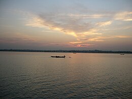
納夫河
納夫河(孟加拉語:নাফ নদী Naf NodiIPA:[naf nod̪i]、緬甸語:နတ္ျမစ္ [naʔ mjɪʔ]、若開語:နတ္ျမစ္ [nɛ́ mràɪʔ]),是緬甸和孟加拉國的界河[1]。
| 納夫河 | |
|---|---|
 | |
| 國家 | |
| 流域 | |
| 河口 | |
| • 位置 | 孟加拉灣 |
| • 座標 | 20°43′N 92°22′E / 20.717°N 92.367°E |
| 本貌 | |
| 深度 | |
| • 平均深度 | 128英尺(39公尺) |
| • 最大深度 | 400英尺(120公尺) |
納夫河平均深度128英尺(39公尺),最深可達400英尺(120公尺),在孟加拉吉大港專區的科克斯巴扎爾縣和緬甸若開邦之間流動,最後注入孟加拉灣。
參考資料
編輯- ^ Sifatul Quader Chowdhury, Naf River, Sirajul Islam and Ahmed A. Jamal (編), Banglapedia: National Encyclopedia of Bangladesh Second, Asiatic Society of Bangladesh, 2012 [2018-11-18], (原始內容存檔於2021-01-22)
- ^ Backgrounder: the Rohingya of Myanmar - Geopoliticalmonitor.com. Geopoliticalmonitor.com. [2018-11-18]. (原始內容存檔於2021-02-13).
- ^ Burma: Mass Arrests, Raids on Rohingya Muslims, Human Rights Watch, July 5, 2012