威奇托 (堪薩斯州)
美国堪萨斯州最大城市
此條目可參照英語維基百科相應條目來擴充。 (2017年2月4日) |
威奇托(英語:Wichita,又譯威啓達或威奇塔)是位於美國堪薩斯州塞奇威克縣阿肯色河畔的一座城市,是該州最大城市和塞奇威克縣的縣治。威奇托是美國主要的飛機製造中樞和文化中心,擁有五家飛機製造商和麥康奈爾空軍基地,因此也被稱為「航空首都(Air Capital)」。曼秀雷敦最早在此城市創立。現代化速食店的發明者白城堡漢堡店與必勝客比薩最早也在此城市創立。威奇托不是堪薩斯州的首府。
| 威奇托 Wichita | |
|---|---|
| 城市 | |
| 綽號:世界空中之都[1]、ICT[2] | |
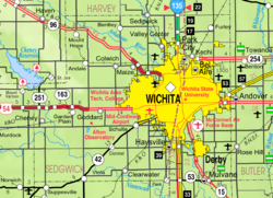
 在堪薩斯州和塞奇威克縣的位置 | |
 KDOT塞奇威克縣(圖示) | |
| 坐標:37°41′20″N 97°20′10″W / 37.68889°N 97.33611°W[3] | |
| 國家 | |
| 州 | |
| 縣 | 塞克威克縣 |
| 建立 | 1868年 |
| 建制 | 1870年 |
| 語源 | 威奇托人 |
| 政府 | |
| • 類型 | 議會-經理制政府 |
| • 市長 | 布蘭登·惠普 ( |
| • 城市經理 | Robert Layton |
| 面積[4] | |
| • 城市 | 431.28 平方公里(166.52 平方哩) |
| • 陸地 | 419.55 平方公里(161.99 平方哩) |
| • 水域 | 11.73 平方公里(4.53 平方哩) |
| 海拔[3] | 397 米(1,303 呎) |
| 人口(2020)[5][6] | |
| • 城市 | 397,532人 |
| • 估計(2021)[7] | 3,956,991 |
| • 排名 | 全美第49、全州第1 |
| • 市區 | 500,231(全美第84) |
| • 市區密度 | 851.4人/平方公里(2,205.2人/平方哩) |
| • 都會區 | 647,919(全美第93) |
| 居民稱謂 | 威奇托人(Wichitan) |
| 時區 | CST(UTC−6) |
| • 夏時制 | CDT(UTC−5) |
| 郵政編號 | 67201-67221, 67223, 67226-67228, 67230, 67232, 67235, 67260, 67275-67278[8] |
| 電話區號 | 316 |
| FIPS編號 | 20-79000 [3] |
| GNIS ID | 473862 [3] |
| 網站 | www |
地理
編輯| 堪薩斯州威奇托德懷特·D·艾森豪威爾國家機場(1991–2020年正常值,1894年至今極端數據) | |||||||||||||
|---|---|---|---|---|---|---|---|---|---|---|---|---|---|
| 月份 | 1月 | 2月 | 3月 | 4月 | 5月 | 6月 | 7月 | 8月 | 9月 | 10月 | 11月 | 12月 | 全年 |
| 歷史最高溫 °C(°F) | 24 (75) |
31 (87) |
33 (92) |
37 (98) |
39 (102) |
43 (110) |
45 (113) |
46 (114) |
42 (108) |
36 (97) |
30 (86) |
28 (83) |
46 (114) |
| 平均最高溫 °C(°F) | 18.8 (65.8) |
22.0 (71.6) |
26.6 (79.9) |
29.6 (85.3) |
33.3 (92.0) |
36.9 (98.4) |
39.8 (103.7) |
39.0 (102.2) |
36.3 (97.3) |
31.7 (89.0) |
24.2 (75.5) |
18.5 (65.3) |
40.5 (104.9) |
| 平均高溫 °C(°F) | 6.6 (43.9) |
9.4 (48.9) |
15.1 (59.1) |
20.2 (68.3) |
25.3 (77.5) |
31.1 (87.9) |
33.7 (92.6) |
32.8 (91.0) |
28.5 (83.3) |
21.6 (70.8) |
13.9 (57.0) |
7.7 (45.8) |
20.5 (68.8) |
| 平均低溫 °C(°F) | −5.3 (22.5) |
−3.2 (26.3) |
2.1 (35.7) |
7.1 (44.8) |
13.3 (55.9) |
18.8 (65.9) |
21.3 (70.4) |
20.4 (68.8) |
15.6 (60.1) |
8.4 (47.2) |
1.5 (34.7) |
−3.7 (25.4) |
8.0 (46.5) |
| 平均最低溫 °C(°F) | −14.9 (5.1) |
−13.1 (8.4) |
−8.3 (17.1) |
−2.1 (28.2) |
4.7 (40.5) |
12.2 (53.9) |
16.3 (61.4) |
15.2 (59.3) |
7.0 (44.6) |
−1.3 (29.7) |
−7.8 (17.9) |
−13.1 (8.4) |
−17.2 (1.0) |
| 歷史最低溫 °C(°F) | −26 (−15) |
−30 (−22) |
−19 (−3) |
−9 (15) |
−3 (27) |
6 (43) |
11 (51) |
7 (45) |
−1 (31) |
−10 (14) |
−17 (1) |
−27 (−16) |
−30 (−22) |
| 平均降水量 mm(吋) | 22 (0.85) |
30 (1.20) |
58 (2.30) |
79 (3.10) |
131 (5.17) |
125 (4.93) |
101 (3.98) |
109 (4.30) |
77 (3.05) |
72 (2.85) |
35 (1.36) |
31 (1.22) |
871 (34.31) |
| 平均降雪量 cm(吋) | 6.9 (2.7) |
9.1 (3.6) |
5.3 (2.1) |
0.51 (0.2) |
0.0 (0.0) |
0.0 (0.0) |
0.0 (0.0) |
0.0 (0.0) |
0.0 (0.0) |
0.51 (0.2) |
2.0 (0.8) |
7.9 (3.1) |
32 (12.7) |
| 平均降水天數(≥ 0.01 in) | 4.8 | 5.3 | 7.4 | 8.3 | 11.3 | 9.5 | 8.3 | 8.2 | 6.9 | 6.6 | 5.1 | 5.4 | 87.1 |
| 平均降雪天數(≥ 0.1 in) | 2.7 | 2.2 | 1.0 | 0.3 | 0.0 | 0.0 | 0.0 | 0.0 | 0.0 | 0.2 | 0.6 | 2.2 | 9.2 |
| 平均相對濕度(%) | 71 | 68 | 66 | 65 | 70 | 66 | 61 | 62 | 65 | 65 | 70 | 73 | 67 |
| 月均日照時數 | 190.9 | 186.4 | 230.4 | 257.8 | 289.8 | 305.0 | 342.1 | 309.2 | 245.6 | 226.3 | 170.2 | 168.7 | 2,922.4 |
| 可照百分比 | 62 | 62 | 62 | 65 | 66 | 69 | 76 | 73 | 66 | 65 | 56 | 57 | 66 |
| 數據來源:NOAA(1981–2010年相對濕度;1961–1990年日照)[9][10][11][12] | |||||||||||||
參考文獻
編輯- ^ Harris, Richard. The Air Capital Story: Early General Aviation & Its Manufacturers. In Flight USA. 2002 [2020-11-17]. (原始內容存檔於2016-03-06).
- ^ Travel Translator: Your guide to the local language in Wichita. VisitWichita.com. [2019-05-13]. (原始內容存檔於2021-01-16).
- ^ 3.0 3.1 3.2 3.3 Geographic Names Information System (GNIS) details for Wichita, Kansas; United States Geological Survey (USGS); October 13, 1978.
- ^ US Gazetteer files 2010. United States Census Bureau. [2012-07-06]. (原始內容存檔於2012-07-02).
- ^ Profile of Wichita, Kansas in 2020. United States Census Bureau. [November 14, 2021]. (原始內容存檔於November 14, 2021).
- ^ QuickFacts; Wichita, Kansas; Population, Census, 2020 & 2010. United States Census Bureau. [August 21, 2021]. (原始內容存檔於August 22, 2021).
- ^ City and Town Population Totals: 2020-2021. United States Census Bureau. May 29, 2022 [May 31, 2022]. (原始內容存檔於2022-07-11).
- ^ United States Postal Service. USPS - Look Up a ZIP Code. 2012 [2012-02-15]. (原始內容存檔於2012-02-14).
- ^ Summary of Monthly Normals 1991–2020 (pdf). National Oceanic and Atmospheric Administration. [2021-11-19]. (原始內容存檔於2021-11-19).
- ^ NowData - NOAA Online Weather Data. National Oceanic and Atmospheric Administration. [2021-11-19]. (原始內容存檔於2022-01-20).
- ^ WMO Climate Normals for WICHITA/MID-CONTINENT ARPT KS 1961–1990. National Oceanic and Atmospheric Administration. [2014-03-11]. (原始內容存檔於2020-10-31).
- ^ Local Climatological Data Annual Summary with Comparative Data for WICHITA, KANSAS (KICT) (PDF). National Oceanic and Atmospheric Administration: 3. [2022-06-12].


