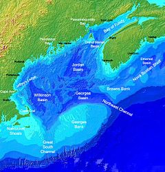
緬因灣
緬因灣(英語:Gulf of Maine)是大西洋西部、美國和加拿大之間的一個大海灣,灣內最大水深200米,自然環境好,又有陸上徑流注入,魚類資源豐富[1][2]。美國和加拿大在60至70年代曾為該地區的大陸架劃界和漁業資源發生過爭執,由國際法院於80年代作出裁決解決。
| 緬因灣 Gulf of Maine Golfe du Maine | |
|---|---|
 | |
| 位置 | 北大西洋西岸 |
| 座標 | 43°N 68°W / 43°N 68°W |
| 類型 | 海灣 |
| 屬於 | 北大西洋 |
| 河流源 | 聖約翰河、佩諾布斯科特河 |
| 集水面積 | 69,000平方哩(180,000平方公里) |
| 所在國家 | 加拿大和美國 |
| 表面積 | 36,000平方哩(93,000平方公里) |
| 島嶼 | 芒特迪瑟特島、福克斯島(Fox Islands)、歐亞爾薩斯島、大馬南島 |
| 聚居地 | 波士頓、樸茨茅夫、波特蘭、聖約翰 |
參考文獻
編輯- ^ About the Gulf of Maine | Gulf of Maine Association. [2022-04-05]. (原始內容存檔於2024-07-15) (美國英語).
- ^ A. Bogomolni; G. Early; K. Matassa; O. Nichols; L. Sette. Gulf of Maine Seals - populations, problems and priorities (PDF). Woods Hole Oceanographic Institution. June 1, 2010: 81. OCLC 672010623. doi:10.1575/1912/3701. (原始內容存檔 (PDF)於May 30, 2021).
- ^ Journal of the Senate (PDF). State of Maine, HP1629, item 1, 123rd Maine State Legislature. March 6, 2002 [September 20, 2007]. (原始內容存檔 (PDF)於2016-10-21).
WHEREAS, the State of Maine is named after the Province of Maine in France...
