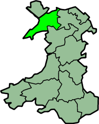
卡那封郡
威尔士历史郡
卡那封郡(英语:Caernarfonshire,威尔士语:Sir Gaernarfon)是威尔士的13个历史上的郡之一,其北面是爱尔兰海,南面是卡迪根湾,西面是卡那封湾和梅奈海峡,大部分地区是山地[2]。
| Caernarfonshire 威尔士语:Sir Gaernarfon | |
|---|---|
 旗帜 | |
 在威尔士的位置 | |
| 坐标:53°04′57″N 4°09′36″W / 53.0824°N 4.16°W | |
| 面积 | |
| • 1831 | 370,273英亩(1,498.44平方千米) |
| • 1911 | 365,986英亩(1,481.09平方千米) |
| • 1961 | 364,108英亩(1,473.49平方千米) |
| 人口 | |
| • 1831 | 66,448[1] |
| • 1911 | 125,043 |
| • 1961 | 121,767 |
| 密度 | |
| • 1831 | 0.2/acre |
| • 1911 | 0.3/acre |
| • 1961 | 0.3/acre |
| Chapman code | CAE |
| 政府 | Carnarvonshire County Council (1889 - 1926) Caernarvonshire County Council (1926-1974) |
| • 行政中心 | 加拿分 |
| • 座右铭 | Cadernid Gwynedd (The strength of Gwynedd) |
Coat of arms of Caernarvonshire County Council | |
参考资料
编辑- ^ Vision of Britain - 1831 Census (页面存档备份,存于互联网档案馆)
- ^ Samuel Lewis (editor). Carnarvonshire. A Topographical Dictionary of Wales. British History Online. 1849 [2008-07-27]. (原始内容存档于2014-08-14).