莫农加希拉河
美国河流
莫农加希拉河(英語:Monongahela River,/məˌnɒnɡəˈhiːlə/[10],在当地也被称为the Mon /ˈmɒn/)是一条长130英里(210公里)[7]的河流,流经西維吉尼亞州中北部和宾夕法尼亚州西南部,在匹兹堡与阿勒格尼河汇合形成俄亥俄河。
| 莫农加希拉河 Monongahela River | |
|---|---|
 穿过匹兹堡的莫农加希拉河 | |
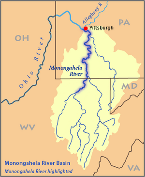
 莫农加希拉河流域图,高亮为莫农加希拉河 | |
| 國家 | |
| 州 | |
| 县 | 馬里昂縣、莫農加利亞縣、格林縣、费耶特县、華盛頓縣、威斯特摩蘭縣、阿利根尼縣 |
| 流域 | |
| 源頭 | 泰加特河 |
| • 位置 | 西弗吉尼亚州波卡洪塔斯縣 |
| • 坐标 | 38°28′06″N 79°58′51″W / 38.46833°N 79.98083°W[3] |
| • 海拔 | 4,540英尺(1,380米)[1] |
| 第二源头 | 西叉河 |
| • 位置 | 西弗吉尼亚州厄普舍縣 |
| • 坐标 | 38°51′08″N 80°21′32″W / 38.85222°N 80.35889°W[5] |
| • 海拔 | 1,309英尺(399米)[4] |
| 河口 | 俄亥俄河 |
| • 位置 | 宾夕法尼亚州匹兹堡 |
| • 坐标 | 40°26′30″N 80°00′58″W / 40.44167°N 80.01611°W[2] |
| • 海拔 | 709英尺(216米)[2] |
| 流域面積 | 7,340 sq mi(19,000 km2)[6] |
| 本貌 | |
| 長度 | 130 mi(210 km)[7] |
| 流量 | |
| • 地點 | 布拉多克 |
| • 平均流量 | 12,650 cu ft/s(358 m3/s)[8] |
| • 最小流量 | 2,900 cu ft/s(82 m3/s) |
| • 最大流量 | 81,100 cu ft/s(2,300 m3/s) |
| 流量 | |
| • 平均流量 | 8,433 cu ft/s(238.8 m3/s)[9] |
| 特徵 | |
| 左岸支流 | 彼得斯克里克、Streets Run、Becks Run |
| 右岸支流 | Cheat River、雅克格尼河、龟溪 |
参考文献
编辑- ^ Google Earth elevation for GNIS source coordinates. Retrieved on March 12, 2007.
- ^ 2.0 2.1 Geographic Names Information System. Geographic Names Information System entry for Monongahela River (Feature ID #1209053). [2007-03-12]. (原始内容存档于2021-10-30).
- ^ Geographic Names Information System. Geographic Names Information System entry for Tygart Valley River (Feature ID #1553309). [2007-03-12]. (原始内容存档于2021-11-06).
- ^ Geographic Names Information System. Geographic Names Information System entry for Straight Fork (headwaters tributary of West Fork River) (Feature ID #1547564). [2007-03-12]. (原始内容存档于2021-11-06).
- ^ Geographic Names Information System. Geographic Names Information System entry for West Fork River (Feature ID #1548931). [2007-03-12]. (原始内容存档于2021-11-06).
- ^ Gillespie, William H. Monongahela River. Ken Sullivan (ed.) (编). The West Virginia Encyclopedia. Charleston, W.Va.: West Virginia Humanities Council. 2006: 492. ISBN 0-9778498-0-5.
- ^ 7.0 7.1 U.S. Geological Survey. National Hydrography Dataset high-resolution flowline data. The National Map (页面存档备份,存于互联网档案馆), accessed August 15, 2011
- ^ United States Geological Survey; USGS 03085000 Monongahela River at Braddock, PA (页面存档备份,存于互联网档案馆); retrieved Sep 29, 2010.
- ^ United States Geological Survey; USGS 03072655 Monongahela River near Masontown, PA (页面存档备份,存于互联网档案馆); retrieved September 29, 2010.
- ^ There are several ways to pronounce this word that are acceptable. From "Geographical Names" of Merriam-Webster's Collegiate Dictionary, Eleventh Edition (2009): /məˌnɒnɡəˈhiːlə/, /məˌnɒŋɡəˈhiːlə/ or /məˌnɒŋɡəˈheɪlə/.