用戶:Mildwall/月球軌道器1號
 | |
| 任務類型 | Lunar orbiter |
|---|---|
| 運營方 | NASA |
| 國際衛星標識符 | 1966-073A |
| 衛星目錄序號 | 2394 |
| 任務時長 | 80天 |
| 航天器屬性 | |
| 製造方 | The Boeing Co. |
| 發射質量 | 385.6公斤(850磅) |
| 任務開始 | |
| 發射日期 | 1966年8月10日 19:31 UTC[1] |
| 運載火箭 | Atlas SLV-3 Agena-D |
| 發射場 | Cape Canaveral LC-13 |
| 任務結束 | |
| 丟棄形式 | Deorbited |
| 離軌日期 | 1966年10月29日 |
| 軌道參數 | |
| 參照系 | Selenocentric |
| 半長軸 | 2,694 km(1,674 mi) |
| 離心率 | 0.33 |
| 近selene點 | 189.1至40.5 km(117.5至25.2 mi) |
| 遠selene點 | 1,866.8 km(1,160.0 mi) |
| 傾角 | 12 degrees |
| 週期 | 208.1 minutes |
| Lunar軌道器 | |
| 入軌 | August 14, 1966 |
| 撞擊點 | 6°21′N 160°43′E / 6.35°N 160.72°E |
| 軌道 | 577 |
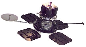
The Lunar Orbiter 1 robotic (unmanned) spacecraft, part of the Lunar Orbiter Program, was the first American spacecraft to orbit the Moon. It was designed primarily to photograph smooth areas of the lunar surface for selection and verification of safe landing sites for the Surveyor and Apollo missions. It was also equipped to collect selenodetic, radiation intensity, and micrometeoroid impact data.
The spacecraft was placed in an Earth parking orbit on August 10, 1966, at 19:31 UTC. The trans-lunar injection burn occurred at 20:04 UTC. The spacecraft experienced a temporary failure of the Canopus star tracker (probably due to stray sunlight) and overheating during its cruise to the Moon. The star tracker problem was resolved by navigating using the Moon as a reference, and the overheating was abated by orienting the spacecraft 36 degrees off-Sun to lower the temperature.
Lunar Orbiter 1 was injected into an elliptical near-equatorial lunar orbit 92.1 hours after launch. The initial orbit was 189.1乘1,866.8公里(117.5乘1,160.0英里) and had a period of 3 hours 37 minutes and an inclination of 12.2 degrees. On August 21, perilune was dropped to 58 km(36 mi) and on August 25 to 40.5 km(25.2 mi). The spacecraft acquired photographic data from August 18 to 29, 1966, and readout occurred through September 14, 1966.

A total of 42 high-resolution and 187 medium-resolution frames were taken and transmitted to Earth covering over 5 million square kilometers of the Moon's surface, accomplishing about 75% of the intended mission, although a number of the early high-resolution photos showed severe smearing. It also took the first two pictures of the Earth ever from the distance of the Moon. Accurate data were acquired from all other experiments throughout the mission.
Orbit tracking showed a slight "pear-shape" of the Moon based on the gravity field, and no micrometeorite impacts were detected. The spacecraft was tracked until it impacted the lunar surface on command at 7 degrees north latitude, 161 degrees east longitude (selenographic coordinates) on the Moon's far side on October 29, 1966, on its 577th orbit. The early end of the nominal one-year mission was due to the small amount of remaining attitude control gas and other deteriorating conditions and was planned to avoid transmission interference with Lunar Orbiter 2.
| Lunar Photographic Studies | Evaluation of Apollo and Surveyor landing sites |
|---|---|
| Meteoroid Detectors | Detection of micrometeoroids in the lunar environment |
| Caesium Iodide Dosimeters | Radiation environment en route to and near the Moon |
| Selenodesy | Gravitational field and physical properties of the Moon |
-
The first ever image of Earth from the distance of the Moon, August 23, 1966. This probe took a second such image on August 25.
-
Part of the photo to the left as reprocessed by LOIRP in 2008.
See also
編輯References
編輯- ^ Lunar Orbiter I: Extended Mission Spacecraft Subsystem Performance (PDF) (報告). NASA. The Boeing Company: 37. September 1967. NASA CR-870.
External links
編輯- Destination Moon: A History of the Lunar Orbiter Program (1976) by the NASA History Office
- Lunar Orbiter Photo Gallery - Mission 1 by the Lunar and Planetary Institute
Template:Lunar Orbiter program

